
Geographic Region: USA-GEORGIA
Feature: CALHOUN & DALTON, MTS,R.
|
Geographic Region: USA-GEORGIA Feature: CALHOUN & DALTON, MTS,R. |
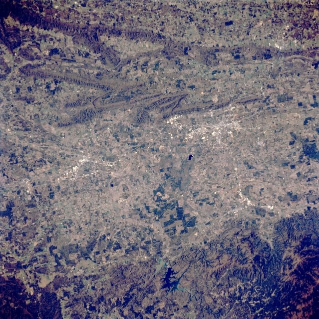 |
| STS062-083-063 Northwest Georgia, U.S.A. March 1994 A broad, mainly cultivated, north-south-oriented valley is apparent in this low-oblique photograph of the northwest corner of Georgia. A segment of Interstate Highway 75 along the western side of valley connects the rural communities of Dalton (clustered, lighter area to the north) and Calhoun (smaller, lighter cluster to the south). East of the highway is dark, irregular-shaped Carters Lake (bottom center). Several linear mountain ridges and valleys lie west of the broad valley. The more uniform, darker area (bottom right corner) is part of the Chattahoochie National Forest and the Blue Ridge Mountains. |
| Images: | All Available Images Low-Resolution 429k |
|
| Mission: | STS062 |
|
| Roll - Frame: | 83 - 63 |
|
| Geographical Name: | USA-GEORGIA |
|
| Features: | CALHOUN & DALTON, MTS,R. |
|
| Center Lat x Lon: | 34.0N x 85W |
|
| Film Exposure: | N | N=Normal exposure, U=Under exposed, O=Over exposed, F=out of Focus |
| Percentage of Cloud Cover-CLDP: | 0 |
|
| Camera:: | HB |
|
| Camera Tilt: | 24 | LO=Low Oblique, HO=High Oblique, NV=Near Vertical |
| Camera Focal Length: | 250 |
|
| Nadir to Photo Center Direction: | S | The direction from the nadir to the center point, N=North, S=South, E=East, W=West |
| Stereo?: | Y | Y=Yes there is an adjacent picture of the same area, N=No there isn't |
| Orbit Number: | 20 |
|
| Date: | 19940305 | YYYYMMDD |
| Time: | 185146 | GMT HHMMSS |
| Nadir Lat: | 35.2N |
Latitude of suborbital point of spacecraft |
| Nadir Lon: | 85.1W |
Longitude of suborbital point of spacecraft |
| Sun Azimuth: | 202 | Clockwise angle in degrees from north to the sun measured at the nadir point |
| Space Craft Altitude: | 162 | nautical miles |
| Sun Elevation: | 47 | Angle in degrees between the horizon and the sun, measured at the nadir point |
| Land Views: | VALLEY, MOUNTAIN, FOREST |
|
| Water Views: | RESERVOIR |
|
| Atmosphere Views: | |
|
| Man Made Views: | |
|
| City Views: | |
|
Photo is not associated with any sequences | ||
| NASA Home Page |
JSC Home Page |
JSC Digital Image Collection |
Earth Science & Remote Sensing |
|
This service is provided by the International Space Station program and the JSC Earth Science & Remote Sensing Unit, ARES Division, Exploration Integration Science Directorate.

|