
Geographic Region: USA-ALABAMA
Feature: GUNTERSVILLE L. ON TN. R.
|
Geographic Region: USA-ALABAMA Feature: GUNTERSVILLE L. ON TN. R. |
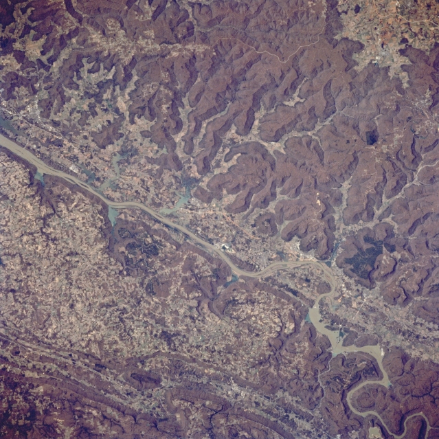 |
| STS062-083-061 Tennessee River, Alabama, U.S.A. March 1994 The northeast-southwest-trending mountains of the Cumberland Plateau and the southern Appalachians determine the direction of the southwest-flowing Tennessee River in northeastern Alabama. Distinctive in appearance are the low mountains on the northwest side of the Tennessee River and the paralleling mountain ridges and valleys southeast of the river. Thin, linear U.S. Highway 72, the major land route between Huntsville, Alabama, and Chattanooga, Tennessee, roughly parallels the Tennessee River on the northwest side of the river. |
| Images: | All Available Images Low-Resolution 389k |
|
| Mission: | STS062 |
|
| Roll - Frame: | 83 - 61 |
|
| Geographical Name: | USA-ALABAMA |
|
| Features: | GUNTERSVILLE L. ON TN. R. |
|
| Center Lat x Lon: | 34.0N x 86W |
|
| Film Exposure: | N | N=Normal exposure, U=Under exposed, O=Over exposed, F=out of Focus |
| Percentage of Cloud Cover-CLDP: | 0 |
|
| Camera:: | HB |
|
| Camera Tilt: | 27 | LO=Low Oblique, HO=High Oblique, NV=Near Vertical |
| Camera Focal Length: | 250 |
|
| Nadir to Photo Center Direction: | S | The direction from the nadir to the center point, N=North, S=South, E=East, W=West |
| Stereo?: | Y | Y=Yes there is an adjacent picture of the same area, N=No there isn't |
| Orbit Number: | 20 |
|
| Date: | 19940305 | YYYYMMDD |
| Time: | 185134 | GMT HHMMSS |
| Nadir Lat: | 35.4N |
Latitude of suborbital point of spacecraft |
| Nadir Lon: | 86W |
Longitude of suborbital point of spacecraft |
| Sun Azimuth: | 201 | Clockwise angle in degrees from north to the sun measured at the nadir point |
| Space Craft Altitude: | 162 | nautical miles |
| Sun Elevation: | 47 | Angle in degrees between the horizon and the sun, measured at the nadir point |
| Land Views: | MOUNTAIN |
|
| Water Views: | RIVER |
|
| Atmosphere Views: | |
|
| Man Made Views: | HIGHWAY |
|
| City Views: | |
|
Photo is not associated with any sequences | ||
| NASA Home Page |
JSC Home Page |
JSC Digital Image Collection |
Earth Science & Remote Sensing |
|
This service is provided by the International Space Station program and the JSC Earth Science & Remote Sensing Unit, ARES Division, Exploration Integration Science Directorate.

|