
Geographic Region: USA-OKLAHOMA
Feature: PONCA CITY,R,FLINT HILLS
|
Geographic Region: USA-OKLAHOMA Feature: PONCA CITY,R,FLINT HILLS |
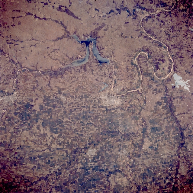 |
| STS062-083-048 Ponca City, Arkansas River, and Kaw Lake, Oklahoma, U.S.A. March 1994 This east-looking, low-oblique photograph features the Arkansas River as it meanders generally southeastward from Arkansas City, Kansas, (left center) through Kaw Lake, past Ponca City and Sooner Lake, toward Tulsa (upper right). Ponca City, founded in 1893 after the opening of the Oklahoma Territory in 1889, is a trade, processing, and shipping hub in a grain, livestock, and oil area. Other manufactures include clothing, oil drilling equipment, and food processing products. Visible are the extreme southern portions of the gently rolling, grass-covered Flint Hills (upper left). |
| Images: | All Available Images Low-Resolution 396k |
|
| Mission: | STS062 |
|
| Roll - Frame: | 83 - 48 |
|
| Geographical Name: | USA-OKLAHOMA |
|
| Features: | PONCA CITY,R,FLINT HILLS |
|
| Center Lat x Lon: | 36.5N x 97W |
|
| Film Exposure: | N | N=Normal exposure, U=Under exposed, O=Over exposed, F=out of Focus |
| Percentage of Cloud Cover-CLDP: | 0 |
|
| Camera:: | HB |
|
| Camera Tilt: | 28 | LO=Low Oblique, HO=High Oblique, NV=Near Vertical |
| Camera Focal Length: | 250 |
|
| Nadir to Photo Center Direction: | S | The direction from the nadir to the center point, N=North, S=South, E=East, W=West |
| Stereo?: | Y | Y=Yes there is an adjacent picture of the same area, N=No there isn't |
| Orbit Number: | 20 |
|
| Date: | 19940305 | YYYYMMDD |
| Time: | 184904 | GMT HHMMSS |
| Nadir Lat: | 37.9N |
Latitude of suborbital point of spacecraft |
| Nadir Lon: | 97.3W |
Longitude of suborbital point of spacecraft |
| Sun Azimuth: | 183 | Clockwise angle in degrees from north to the sun measured at the nadir point |
| Space Craft Altitude: | 161 | nautical miles |
| Sun Elevation: | 46 | Angle in degrees between the horizon and the sun, measured at the nadir point |
| Land Views: | PLAIN |
|
| Water Views: | RIVER, LAKE |
|
| Atmosphere Views: | |
|
| Man Made Views: | AGRICULTURE, URBAN AREA |
|
| City Views: | |
|
Photo is not associated with any sequences | ||
| NASA Home Page |
JSC Home Page |
JSC Digital Image Collection |
Earth Science & Remote Sensing |
|
This service is provided by the International Space Station program and the JSC Earth Science & Remote Sensing Unit, ARES Division, Exploration Integration Science Directorate.

|