
Geographic Region: USA-TEXAS
Feature: HOUSTON-GALVESTON AREA
|
Geographic Region: USA-TEXAS Feature: HOUSTON-GALVESTON AREA |
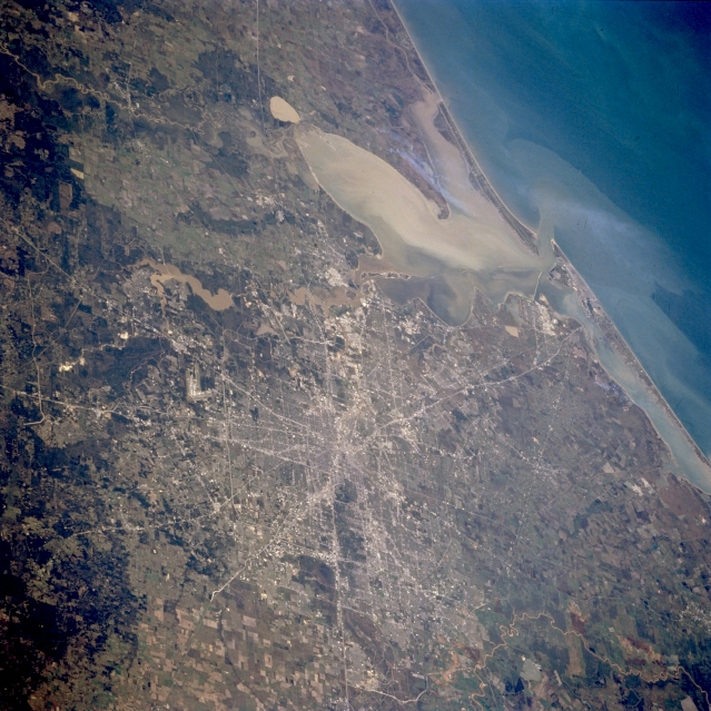 |
| STS062-082-104 Houston, Texas, U.S.A. March 1994 This southeast-looking photograph depicts the flat coastal plain surrounding rapidly developing Houston. Major highway systems converging near downtown, Galveston Bay, and the Gulf of Mexico provide worldwide land and water connections. An extensive sediment plume in Galveston Bay has a small extension of the plume bleeding into the Gulf of Mexico. Visible are large cultivated fields west of Houston, mainly north of Interstate Highway 10; dark, forested lands, primarily pine forests, to the north; and muddy Lake Houston, a reservoir on the San Jacinto River, to the northeast. |
| Images: | All Available Images Low-Resolution 365k |
|
| Mission: | STS062 |
|
| Roll - Frame: | 82 - 104 |
|
| Geographical Name: | USA-TEXAS |
|
| Features: | HOUSTON-GALVESTON AREA |
|
| Center Lat x Lon: | 29.5N x 95.5W |
|
| Film Exposure: | N | N=Normal exposure, U=Under exposed, O=Over exposed, F=out of Focus |
| Percentage of Cloud Cover-CLDP: | 0 |
|
| Camera:: | HB |
|
| Camera Tilt: | 53 | LO=Low Oblique, HO=High Oblique, NV=Near Vertical |
| Camera Focal Length: | 250 |
|
| Nadir to Photo Center Direction: | SE | The direction from the nadir to the center point, N=North, S=South, E=East, W=West |
| Stereo?: | Y | Y=Yes there is an adjacent picture of the same area, N=No there isn't |
| Orbit Number: | 99 |
|
| Date: | 19940310 | YYYYMMDD |
| Time: | 175616 | GMT HHMMSS |
| Nadir Lat: | 31.7N |
Latitude of suborbital point of spacecraft |
| Nadir Lon: | 98.3W |
Longitude of suborbital point of spacecraft |
| Sun Azimuth: | 160 | Clockwise angle in degrees from north to the sun measured at the nadir point |
| Space Craft Altitude: | 161 | nautical miles |
| Sun Elevation: | 53 | Angle in degrees between the horizon and the sun, measured at the nadir point |
| Land Views: | PLAIN, COAST |
|
| Water Views: | RESERVOIR, BAY |
|
| Atmosphere Views: | |
|
| Man Made Views: | HIGHWAY, URBAN AREA, AIRPORT |
|
| City Views: | |
|
Photo is not associated with any sequences | ||
| NASA Home Page |
JSC Home Page |
JSC Digital Image Collection |
Earth Science & Remote Sensing |
|
This service is provided by the International Space Station program and the JSC Earth Science & Remote Sensing Unit, ARES Division, Exploration Integration Science Directorate.

|