
Geographic Region: USA-NORTH CAROLINA
Feature: WILMINGTON,CAPE FEAR,SED
|
Geographic Region: USA-NORTH CAROLINA Feature: WILMINGTON,CAPE FEAR,SED |
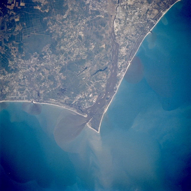 |
| STS062-081-081 Cape Fear, North Carolina, U.S.A. March 1994 The Cape Fear River exhibits a broad floodplain (dark, north-south swath in center of image) as the river drains south along the southeast coast of North Carolina. The mouth of the Cape Fear River can be identified by the fan-shaped sediment plume (dark in color) that extends into the Atlantic Ocean (slightly below the center of the image). Cape Fear is located on the point of land southeast of the mouth of the river. U. S. Highway 17 is the thin, light-colored line that extends across the picture from northeast to southwest. The dark looking landscape (upper left) is an uninhabited marshland known as the Green Swamp. The elongated, dark features near the center of the image and west of the Cape Fear River are part of another swampy area called Boiling Spring Lakes. |
| Images: | All Available Images Low-Resolution 313k |
|
| Mission: | STS062 |
|
| Roll - Frame: | 81 - 81 |
|
| Geographical Name: | USA-NORTH CAROLINA |
|
| Features: | WILMINGTON,CAPE FEAR,SED |
|
| Center Lat x Lon: | 34.0N x 78W |
|
| Film Exposure: | N | N=Normal exposure, U=Under exposed, O=Over exposed, F=out of Focus |
| Percentage of Cloud Cover-CLDP: | 0 |
|
| Camera:: | HB |
|
| Camera Tilt: | 15 | LO=Low Oblique, HO=High Oblique, NV=Near Vertical |
| Camera Focal Length: | 250 |
|
| Nadir to Photo Center Direction: | W | The direction from the nadir to the center point, N=North, S=South, E=East, W=West |
| Stereo?: | Y | Y=Yes there is an adjacent picture of the same area, N=No there isn't |
| Orbit Number: | 17 |
|
| Date: | 19940305 | YYYYMMDD |
| Time: | 140720 | GMT HHMMSS |
| Nadir Lat: | 33.8N |
Latitude of suborbital point of spacecraft |
| Nadir Lon: | 77.3W |
Longitude of suborbital point of spacecraft |
| Sun Azimuth: | 121 | Clockwise angle in degrees from north to the sun measured at the nadir point |
| Space Craft Altitude: | 161 | nautical miles |
| Sun Elevation: | 29 | Angle in degrees between the horizon and the sun, measured at the nadir point |
| Land Views: | CAPE, PLAIN, ISLAND |
|
| Water Views: | RIVER, OCEAN, SWAMP, LAKE |
|
| Atmosphere Views: | |
|
| Man Made Views: | AGRICULTURE, HIGHWAY |
|
| City Views: | |
|
Photo is not associated with any sequences | ||
| NASA Home Page |
JSC Home Page |
JSC Digital Image Collection |
Earth Science & Remote Sensing |
|
This service is provided by the International Space Station program and the JSC Earth Science & Remote Sensing Unit, ARES Division, Exploration Integration Science Directorate.

|