
Geographic Region: USA-FLORIDA
Feature: JACKSONVILLE, ST. JOHN R.
|
Geographic Region: USA-FLORIDA Feature: JACKSONVILLE, ST. JOHN R. |
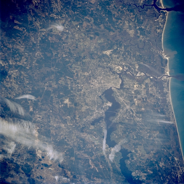 |
| STS062-081-078 Jacksonville, Florida, U.S.A. March 1994 Numerous light, linear ground transportation links (several highways and some railroad rights-of-way) converge on Jacksonville, northeast Florida's largest city. Broad, dark Saint Johns River flows north to Jacksonville, narrows along the southern edge of downtown, and eventually flows eastward to the Atlantic Ocean. Saint Marys River, which originates in the Okefenokee Swamp of southeastern Georgia (dark area in upper left corner) and forms the state boundary for northeast Florida and southeast Georgia, traverses the low-lying, relatively flat terrain north and northwest of Jacksonville. Darker areas show concentrations of wooded, swampy landscapes. Several white cloud patterns are apparent. |
| Images: | All Available Images Low-Resolution 367k |
|
| Mission: | STS062 |
|
| Roll - Frame: | 81 - 78 |
|
| Geographical Name: | USA-FLORIDA |
|
| Features: | JACKSONVILLE, ST. JOHN R. |
|
| Center Lat x Lon: | 30.5N x 82W |
|
| Film Exposure: | N | N=Normal exposure, U=Under exposed, O=Over exposed, F=out of Focus |
| Percentage of Cloud Cover-CLDP: | 5 |
|
| Camera:: | HB |
|
| Camera Tilt: | 35 | LO=Low Oblique, HO=High Oblique, NV=Near Vertical |
| Camera Focal Length: | 250 |
|
| Nadir to Photo Center Direction: | S | The direction from the nadir to the center point, N=North, S=South, E=East, W=West |
| Stereo?: | Y | Y=Yes there is an adjacent picture of the same area, N=No there isn't |
| Orbit Number: | 17 |
|
| Date: | 19940305 | YYYYMMDD |
| Time: | 140621 | GMT HHMMSS |
| Nadir Lat: | 32.3N |
Latitude of suborbital point of spacecraft |
| Nadir Lon: | 81.4W |
Longitude of suborbital point of spacecraft |
| Sun Azimuth: | 117 | Clockwise angle in degrees from north to the sun measured at the nadir point |
| Space Craft Altitude: | 161 | nautical miles |
| Sun Elevation: | 27 | Angle in degrees between the horizon and the sun, measured at the nadir point |
| Land Views: | PLAIN |
|
| Water Views: | RIVER, SWAMP |
|
| Atmosphere Views: | |
|
| Man Made Views: | URBAN AREA, HIGHWAY |
|
| City Views: | |
|
Photo is not associated with any sequences | ||
| NASA Home Page |
JSC Home Page |
JSC Digital Image Collection |
Earth Science & Remote Sensing |
|
This service is provided by the International Space Station program and the JSC Earth Science & Remote Sensing Unit, ARES Division, Exploration Integration Science Directorate.

|