
Geographic Region: AUSTRALIA-SA
Feature: L. ALEXANDRINA, MURRAY R
|
Geographic Region: AUSTRALIA-SA Feature: L. ALEXANDRINA, MURRAY R |
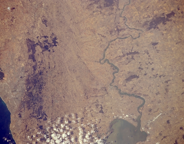 |
| STS062-154-039 Murray River Basin, South Australia, Australia March 1994 The photograph shows three distinct geographic regions that are part of southeast South Australia. From east to west (right to left) these regions are the Murray River Basin (eastern half of the image); the faulted and fractured Mt. Lofty Range; and part of the largest city in South Australia, Adelaide (barely discernible). Sometimes called Australia's Mississippi River, the lower extent of the Murray River is visible as it snakes its way across an agricultural landscape. The Murray River eventually flows into estuarine Lake Alexandrina (near bottom center). The square block of varying shades of brown represent large tracts of land indicative of an important agricultural region. The agriculture includes dairying, vegetable gardening, fruit crops, and wool production. The darker areas (lower left) towards the western side of the Mt. Lofty Range are forest. The very dark areas (upper left) appear to be large cultivated tracts of land, perhaps vineyards. This region has a Mediterranean climate and is noted for its superior wines. |
| Images: | All Available Images Low-Resolution 276k |
|
| Mission: | STS062 |
|
| Roll - Frame: | 154 - 39 |
|
| Geographical Name: | AUSTRALIA-SA |
|
| Features: | L. ALEXANDRINA, MURRAY R |
|
| Center Lat x Lon: | 35S x 139.0E |
|
| Film Exposure: | N | N=Normal exposure, U=Under exposed, O=Over exposed, F=out of Focus |
| Percentage of Cloud Cover-CLDP: | 5 |
|
| Camera:: | LH |
|
| Camera Tilt: | 23 | LO=Low Oblique, HO=High Oblique, NV=Near Vertical |
| Camera Focal Length: | 250 |
|
| Nadir to Photo Center Direction: | E | The direction from the nadir to the center point, N=North, S=South, E=East, W=West |
| Stereo?: | Y | Y=Yes there is an adjacent picture of the same area, N=No there isn't |
| Orbit Number: | 187 |
|
| Date: | 19940316 | YYYYMMDD |
| Time: | 063556 | GMT HHMMSS |
| Nadir Lat: | 34.9S |
Latitude of suborbital point of spacecraft |
| Nadir Lon: | 138.0E |
Longitude of suborbital point of spacecraft |
| Sun Azimuth: | 290 | Clockwise angle in degrees from north to the sun measured at the nadir point |
| Space Craft Altitude: | 140 | nautical miles |
| Sun Elevation: | 30 | Angle in degrees between the horizon and the sun, measured at the nadir point |
| Land Views: | BASIN, MOUNTAIN |
|
| Water Views: | RIVER, LAKE |
|
| Atmosphere Views: | |
|
| Man Made Views: | |
|
| City Views: | |
|
Photo is not associated with any sequences | ||
| NASA Home Page |
JSC Home Page |
JSC Digital Image Collection |
Earth Science & Remote Sensing |
|
This service is provided by the International Space Station program and the JSC Earth Science & Remote Sensing Unit, ARES Division, Exploration Integration Science Directorate.

|