
Geographic Region: USA-FLORIDA
Feature: APALACHICOLA B, SUNGLINT
|
Geographic Region: USA-FLORIDA Feature: APALACHICOLA B, SUNGLINT |
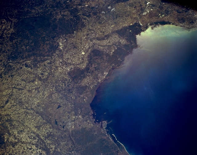 |
| STS062-153-143 Florida Panhandle, U.S.A. March 1994 The dark landscape of the Florida panhandle extends from the eastern half of the Apalachicola National Forest in the west through Saint Marks National Wildlife Refuge that borders the Apalachee Bay to the densely vegetated swampland of the Suwanne River delta and the Lower Suwanne National Wildlife Refuge at the mouth of the Suwanne River. Large, dark Okefenokee Swamp (near upper left corner) is located primarily in southeastern Georgia. Many stream channels can be identified by dense stands of vegetation, primarily woodlands, and lighter areas tend to be agricultural lands. |
| Images: | All Available Images Low-Resolution 268k |
|
| Mission: | STS062 |
|
| Roll - Frame: | 153 - 143 |
|
| Geographical Name: | USA-FLORIDA |
|
| Features: | APALACHICOLA B, SUNGLINT |
|
| Center Lat x Lon: | 30.0N x 84W |
|
| Film Exposure: | N | N=Normal exposure, U=Under exposed, O=Over exposed, F=out of Focus |
| Percentage of Cloud Cover-CLDP: | 0 |
|
| Camera:: | LH |
|
| Camera Tilt: | 28 | LO=Low Oblique, HO=High Oblique, NV=Near Vertical |
| Camera Focal Length: | 90 |
|
| Nadir to Photo Center Direction: | SE | The direction from the nadir to the center point, N=North, S=South, E=East, W=West |
| Stereo?: | Y | Y=Yes there is an adjacent picture of the same area, N=No there isn't |
| Orbit Number: | 161 |
|
| Date: | 19940314 | YYYYMMDD |
| Time: | 151714 | GMT HHMMSS |
| Nadir Lat: | 30.6N |
Latitude of suborbital point of spacecraft |
| Nadir Lon: | 85.1W |
Longitude of suborbital point of spacecraft |
| Sun Azimuth: | 125 | Clockwise angle in degrees from north to the sun measured at the nadir point |
| Space Craft Altitude: | 140 | nautical miles |
| Sun Elevation: | 41 | Angle in degrees between the horizon and the sun, measured at the nadir point |
| Land Views: | FOREST, COAST, PLAIN |
|
| Water Views: | SWAMP, RIVER |
|
| Atmosphere Views: | |
|
| Man Made Views: | |
|
| City Views: | |
|
Photo is not associated with any sequences | ||
| NASA Home Page |
JSC Home Page |
JSC Digital Image Collection |
Earth Science & Remote Sensing |
|
This service is provided by the International Space Station program and the JSC Earth Science & Remote Sensing Unit, ARES Division, Exploration Integration Science Directorate.

|