
Geographic Region: USA-OKLAHOMA
Feature: OUACHITAS, TULSA, AR. R.
|
Geographic Region: USA-OKLAHOMA Feature: OUACHITAS, TULSA, AR. R. |
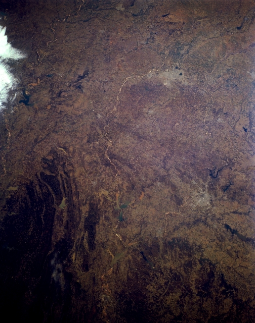 |
| STS062-151-040 Eastern Oklahoma, U.S.A. March 1994 Visible in this panoramic, west-southwest-looking, low-oblique photograph of eastern Oklahoma are the western Ouachita Mountains, which are composed of strongly folded and faulted sedimentary rocks (bottom left); western portions of the dissected Ozark Plateau (bottom right); and Lake of the Cherokees (bottom right). Apparent are Oklahoma City and the Canadian River as it flows generally eastward to join the Arkansas River in Robert S. Kerr Lake (barely discernible) sandwiched between the Ouachita Mountains and the Ozark Plateau. Discernible are Lake Texoma (left center) and the Arbuckle Mountains to its north--a range of low, rolling hills formed in the Precambrian era. |
| Images: | All Available Images Low-Resolution 284k |
|
| Mission: | STS062 |
|
| Roll - Frame: | 151 - 40 |
|
| Geographical Name: | USA-OKLAHOMA |
|
| Features: | OUACHITAS, TULSA, AR. R. |
|
| Center Lat x Lon: | 35.5N x 96.5W |
|
| Film Exposure: | N | N=Normal exposure, U=Under exposed, O=Over exposed, F=out of Focus |
| Percentage of Cloud Cover-CLDP: | 5 |
|
| Camera:: | LH |
|
| Camera Tilt: | 17 | LO=Low Oblique, HO=High Oblique, NV=Near Vertical |
| Camera Focal Length: | 90 |
|
| Nadir to Photo Center Direction: | W | The direction from the nadir to the center point, N=North, S=South, E=East, W=West |
| Stereo?: | Y | Y=Yes there is an adjacent picture of the same area, N=No there isn't |
| Orbit Number: | 18 |
|
| Date: | 19940305 | YYYYMMDD |
| Time: | 153850 | GMT HHMMSS |
| Nadir Lat: | 35.3N |
Latitude of suborbital point of spacecraft |
| Nadir Lon: | 95.7W |
Longitude of suborbital point of spacecraft |
| Sun Azimuth: | 126 | Clockwise angle in degrees from north to the sun measured at the nadir point |
| Space Craft Altitude: | 161 | nautical miles |
| Sun Elevation: | 32 | Angle in degrees between the horizon and the sun, measured at the nadir point |
| Land Views: | PLAIN, MOUNTAIN |
|
| Water Views: | LAKE |
|
| Atmosphere Views: | |
|
| Man Made Views: | |
|
| City Views: | |
|
Photo is not associated with any sequences | ||
| NASA Home Page |
JSC Home Page |
JSC Digital Image Collection |
Earth Science & Remote Sensing |
|
This service is provided by the International Space Station program and the JSC Earth Science & Remote Sensing Unit, ARES Division, Exploration Integration Science Directorate.

|