
Geographic Region: MEXICO
Feature: MONTERREY
|
Geographic Region: MEXICO Feature: MONTERREY |
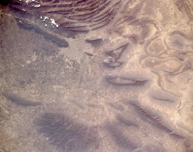 |
| STS062-151-377 Monterrey, Mexico March 1994 Monterrey, capital of Nuevo Leon and Mexico's third largest city (with an estimated 1990 population of 2.5 million), has long been the country's leading industrial center and the principal railroad hub for northeast Mexico. Power line rights-of-way, railroads, and highways can be seen in this near-vertical photograph. Field patterns are visible in the broad valleys east of metropolitan Monterrey. The north-south-trending, folded Sierra Madre Oriental Mountain Range is a series of elongated limestone ranges forming the eastern rim of the elevated Mexican Plateau. The mountains play a key role in Monterrey's environment; for example, severe air pollution problems can develop when air stagnation occurs. Ridges in this mountain range vary from 7000 to 8000 feet (2000 to 2400 meters) in elevation, with some peaks reaching 13 000 feet (4000 meters). The ridges and valleys are the result of geologic folding of bedrock and are similar to the folded Appalachian Mountains of the eastern United States. The Sierra Madre Oriental Range veers westward west of Monterrey, forming an anticlinorium, a spectacular series of folded ridges and valleys. The mountains become more fragmented and eroded north and east of the city. |
| Images: | All Available Images Low-Resolution 110k |
|
| Mission: | STS062 |
|
| Roll - Frame: | 151 - 377 |
|
| Geographical Name: | MEXICO |
|
| Features: | MONTERREY |
|
| Center Lat x Lon: | 25.5N x 100W |
|
| Film Exposure: | N | N=Normal exposure, U=Under exposed, O=Over exposed, F=out of Focus |
| Percentage of Cloud Cover-CLDP: | 5 |
|
| Camera:: | LH |
|
| Camera Tilt: | 6 | LO=Low Oblique, HO=High Oblique, NV=Near Vertical |
| Camera Focal Length: | 250 |
|
| Nadir to Photo Center Direction: | SW | The direction from the nadir to the center point, N=North, S=South, E=East, W=West |
| Stereo?: | Y | Y=Yes there is an adjacent picture of the same area, N=No there isn't |
| Orbit Number: | 84 |
|
| Date: | 19940309 | YYYYMMDD |
| Time: | 192328 | GMT HHMMSS |
| Nadir Lat: | 25.7N |
Latitude of suborbital point of spacecraft |
| Nadir Lon: | 99.8W |
Longitude of suborbital point of spacecraft |
| Sun Azimuth: | 196 | Clockwise angle in degrees from north to the sun measured at the nadir point |
| Space Craft Altitude: | 162 | nautical miles |
| Sun Elevation: | 59 | Angle in degrees between the horizon and the sun, measured at the nadir point |
| Land Views: | MOUNTAIN, FAULT |
|
| Water Views: | |
|
| Atmosphere Views: | |
|
| Man Made Views: | URBAN AREA |
|
| City Views: | MONTERREY |
|
Photo is not associated with any sequences | ||
| NASA Home Page |
JSC Home Page |
JSC Digital Image Collection |
Earth Science & Remote Sensing |
|
This service is provided by the International Space Station program and the JSC Earth Science & Remote Sensing Unit, ARES Division, Exploration Integration Science Directorate.

|