
Geographic Region: USA-CALIFORNIA
Feature: SAN ANDREAS FAULT
|
Geographic Region: USA-CALIFORNIA Feature: SAN ANDREAS FAULT |
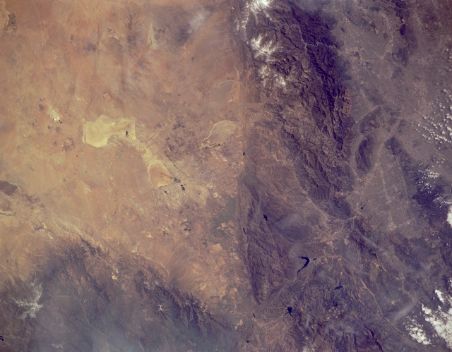 |
| STS062-151-366 San Andreas Fault and San Gabriel Mountains, California, U.S.A. March 1994 The San Andreas Fault is captured in this low-oblique photograph. A great fracture in the Earth's crust and the principal fault in an intricate network of faults extending more than 600 miles (695 kilometers) from northwest California to the Gulf of California, San Andreas is the boundary of the North American Plate to the east and the Pacific Plate to the west. The Pacific Plate, moving northwest in relation to the North American Plate, causes numerous moderate-to-severe earthquakes. Visible west of the fault are the rugged San Gabriel Mountains, and still farther west is Los Angeles with the San Fernando Valley to its north. East of the San Andreas Fault are Rosamond Dry Lake and Rogers Dry Lake. To the northwest appear the Tehachapi Mountains. |
| Images: | All Available Images Low-Resolution 262k |
|
| Mission: | STS062 |
|
| Roll - Frame: | 151 - 366 |
|
| Geographical Name: | USA-CALIFORNIA |
|
| Features: | SAN ANDREAS FAULT |
|
| Center Lat x Lon: | 34.5N x 118W |
|
| Film Exposure: | N | N=Normal exposure, U=Under exposed, O=Over exposed, F=out of Focus |
| Percentage of Cloud Cover-CLDP: | 5 |
|
| Camera:: | LH |
|
| Camera Tilt: | 19 | LO=Low Oblique, HO=High Oblique, NV=Near Vertical |
| Camera Focal Length: | 250 |
|
| Nadir to Photo Center Direction: | NW | The direction from the nadir to the center point, N=North, S=South, E=East, W=West |
| Stereo?: | Y | Y=Yes there is an adjacent picture of the same area, N=No there isn't |
| Orbit Number: | 84 |
|
| Date: | 19940309 | YYYYMMDD |
| Time: | 191854 | GMT HHMMSS |
| Nadir Lat: | 33.7N |
Latitude of suborbital point of spacecraft |
| Nadir Lon: | 117.5W |
Longitude of suborbital point of spacecraft |
| Sun Azimuth: | 163 | Clockwise angle in degrees from north to the sun measured at the nadir point |
| Space Craft Altitude: | 161 | nautical miles |
| Sun Elevation: | 51 | Angle in degrees between the horizon and the sun, measured at the nadir point |
| Land Views: | MOUNTAIN, FAULT, DESERT |
|
| Water Views: | PLAYA |
|
| Atmosphere Views: | |
|
| Man Made Views: | |
|
| City Views: | |
|
Photo is not associated with any sequences | ||
| NASA Home Page |
JSC Home Page |
JSC Digital Image Collection |
Earth Science & Remote Sensing |
|
This service is provided by the International Space Station program and the JSC Earth Science & Remote Sensing Unit, ARES Division, Exploration Integration Science Directorate.

|