
Geographic Region: USA-NORTH CAROLINA
Feature: CAPES LOOKOUT & HATTERAS
|
Geographic Region: USA-NORTH CAROLINA Feature: CAPES LOOKOUT & HATTERAS |
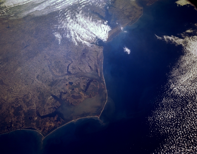 |
| STS062-151-030 Pamlico Sound Area, North Carolina, U.S.A. March 1994 The small scale of this northwest looking image allows the viewing of two river basins that creates most of the wetlands along the North Carolina coast. Several sediment-rich river tributaries are visible as they flow into Pamlico Sound, the large, muddy embayment west of Cape Hatteras, and to a lesser extent into Albemarle Sound, the smaller estuary north of Pamlico Sound. The barrier islands extend from coastal Virginia to Cape Hatteras and Cape Lookout and beyond (southwest-bottom left). In addition to the coastal wetlands of North Carolina, some of the wetlands of Virginia and Maryland are visible, even as far north as Delaware Bay (top right). Unfortunately clouds mask the mouth of Chesapeake Bay. |
| Images: | All Available Images Low-Resolution 251k |
|
| Mission: | STS062 |
|
| Roll - Frame: | 151 - 30 |
|
| Geographical Name: | USA-NORTH CAROLINA |
|
| Features: | CAPES LOOKOUT & HATTERAS |
|
| Center Lat x Lon: | 35.0N x 76W |
|
| Film Exposure: | N | N=Normal exposure, U=Under exposed, O=Over exposed, F=out of Focus |
| Percentage of Cloud Cover-CLDP: | 15 |
|
| Camera:: | LH |
|
| Camera Tilt: | 18 | LO=Low Oblique, HO=High Oblique, NV=Near Vertical |
| Camera Focal Length: | 90 |
|
| Nadir to Photo Center Direction: | NW | The direction from the nadir to the center point, N=North, S=South, E=East, W=West |
| Stereo?: | N | Y=Yes there is an adjacent picture of the same area, N=No there isn't |
| Orbit Number: | 17 |
|
| Date: | 19940305 | YYYYMMDD |
| Time: | 140748 | GMT HHMMSS |
| Nadir Lat: | 34.5N |
Latitude of suborbital point of spacecraft |
| Nadir Lon: | 75.3W |
Longitude of suborbital point of spacecraft |
| Sun Azimuth: | 123 | Clockwise angle in degrees from north to the sun measured at the nadir point |
| Space Craft Altitude: | 161 | nautical miles |
| Sun Elevation: | 31 | Angle in degrees between the horizon and the sun, measured at the nadir point |
| Land Views: | COAST, CAPE, PLAIN, ISLAND |
|
| Water Views: | ESTUARY, RIVER, INLET |
|
| Atmosphere Views: | |
|
| Man Made Views: | |
|
| City Views: | |
|
Photo is not associated with any sequences | ||
| NASA Home Page |
JSC Home Page |
JSC Digital Image Collection |
Earth Science & Remote Sensing |
|
This service is provided by the International Space Station program and the JSC Earth Science & Remote Sensing Unit, ARES Division, Exploration Integration Science Directorate.

|