
Geographic Region: AUSTRALIA-WA
Feature: LAKE MCLEOD, GASCOYNE R.
|
Geographic Region: AUSTRALIA-WA Feature: LAKE MCLEOD, GASCOYNE R. |
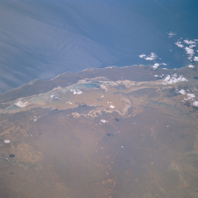 |
| STS062-114-015 Lake Macleod, Western Australia, Australia March 1994 The 370 000 acre (150 000 hectare) bed of Lake Macleod is usually dry, but this image shows brownish-looking shallow water in the central and eastern sections of the lake. The primary water source for Lake Macleod is seawater that passes underground and up into sinkholes on the west side of the lake (turquoise blue areas). Water in the sinkholes is permanent, occasionally flows over land to collect at the south end, and is used for commerical salt production (squared white areas in the center left). Under rare conditions, flows from rivers such as the Lyndon River (greenish band in the center right) or high local precipitation can flood the dry lakebed. Compare this low oblique, west-looking view to STS035-076-040, which is a near vertical look at Lake Macleod during typical dry conditions. |
| Images: | All Available Images Low-Resolution 240k |
|
| Mission: | STS062 |
|
| Roll - Frame: | 114 - 15 |
|
| Geographical Name: | AUSTRALIA-WA |
|
| Features: | LAKE MCLEOD, GASCOYNE R. |
|
| Center Lat x Lon: | 24S x 114.0E |
|
| Film Exposure: | N | N=Normal exposure, U=Under exposed, O=Over exposed, F=out of Focus |
| Percentage of Cloud Cover-CLDP: | 5 |
|
| Camera:: | HB |
|
| Camera Tilt: | LO | LO=Low Oblique, HO=High Oblique, NV=Near Vertical |
| Camera Focal Length: | 40 |
|
| Nadir to Photo Center Direction: | NW | The direction from the nadir to the center point, N=North, S=South, E=East, W=West |
| Stereo?: | Y | Y=Yes there is an adjacent picture of the same area, N=No there isn't |
| Orbit Number: | 140 |
|
| Date: | 19940313 | YYYYMMDD |
| Time: | 080807 | GMT HHMMSS |
| Nadir Lat: | 26.8S |
Latitude of suborbital point of spacecraft |
| Nadir Lon: | 116.8E |
Longitude of suborbital point of spacecraft |
| Sun Azimuth: | 284 | Clockwise angle in degrees from north to the sun measured at the nadir point |
| Space Craft Altitude: | 164 | nautical miles |
| Sun Elevation: | 31 | Angle in degrees between the horizon and the sun, measured at the nadir point |
| Land Views: | |
|
| Water Views: | SEDIMENT, OCEAN, PLAYA |
|
| Atmosphere Views: | |
|
| Man Made Views: | |
|
| City Views: | |
|
Photo is not associated with any sequences | ||
| NASA Home Page |
JSC Home Page |
JSC Digital Image Collection |
Earth Science & Remote Sensing |
|
This service is provided by the International Space Station program and the JSC Earth Science & Remote Sensing Unit, ARES Division, Exploration Integration Science Directorate.

|