
Geographic Region: AUSTRALIA-NT
Feature: SIMPSON DES., FIRE SCARS
|
Geographic Region: AUSTRALIA-NT Feature: SIMPSON DES., FIRE SCARS |
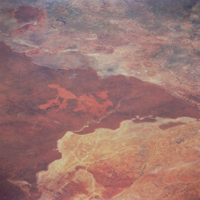 |
| STS062-109-067 Barkly Tableland, Queensland, Australia March 1994 The northeast end of the slightly elevated Barkly Tableland (darker area) shows a marked color contrast in this semiarid landscape roughly 60 miles (97 kilometers) northwest of Mount Isa near the Queensland-Northern Territory border. The dark, V-shaped feature is a slightly elevated, sandy area that is covered by grass. Within this grassland, the lighter colored, reddish patterns are burn scars, probably caused by a lightning strike. Several ephemeral streams can be identified in the lower, flatter regions of the image. |
| Images: | All Available Images Low-Resolution 309k |
|
| Mission: | STS062 |
|
| Roll - Frame: | 109 - 67 |
|
| Geographical Name: | AUSTRALIA-NT |
|
| Features: | SIMPSON DES., FIRE SCARS |
|
| Center Lat x Lon: | N x E |
|
| Film Exposure: | N | N=Normal exposure, U=Under exposed, O=Over exposed, F=out of Focus |
| Percentage of Cloud Cover-CLDP: | 0 |
|
| Camera:: | HB |
|
| Camera Tilt: | LO | LO=Low Oblique, HO=High Oblique, NV=Near Vertical |
| Camera Focal Length: | 250 |
|
| Nadir to Photo Center Direction: | The direction from the nadir to the center point, N=North, S=South, E=East, W=West |
|
| Stereo?: | Y | Y=Yes there is an adjacent picture of the same area, N=No there isn't |
| Orbit Number: | 186 |
|
| Date: | 19940316 | YYYYMMDD |
| Time: | 045952 | GMT HHMMSS |
| Nadir Lat: | 24S |
Latitude of suborbital point of spacecraft |
| Nadir Lon: | 136.6E |
Longitude of suborbital point of spacecraft |
| Sun Azimuth: | 303 | Clockwise angle in degrees from north to the sun measured at the nadir point |
| Space Craft Altitude: | 140 | nautical miles |
| Sun Elevation: | 54 | Angle in degrees between the horizon and the sun, measured at the nadir point |
| Land Views: | PLAIN, DESERT |
|
| Water Views: | RIVER |
|
| Atmosphere Views: | |
|
| Man Made Views: | |
|
| City Views: | |
|
Photo is not associated with any sequences | ||
| NASA Home Page |
JSC Home Page |
JSC Digital Image Collection |
Earth Science & Remote Sensing |
|
This service is provided by the International Space Station program and the JSC Earth Science & Remote Sensing Unit, ARES Division, Exploration Integration Science Directorate.

|