
Geographic Region: EGYPT
Feature: CAIRO, NILE RIVER, AGRICULTURE
|
Geographic Region: EGYPT Feature: CAIRO, NILE RIVER, AGRICULTURE |
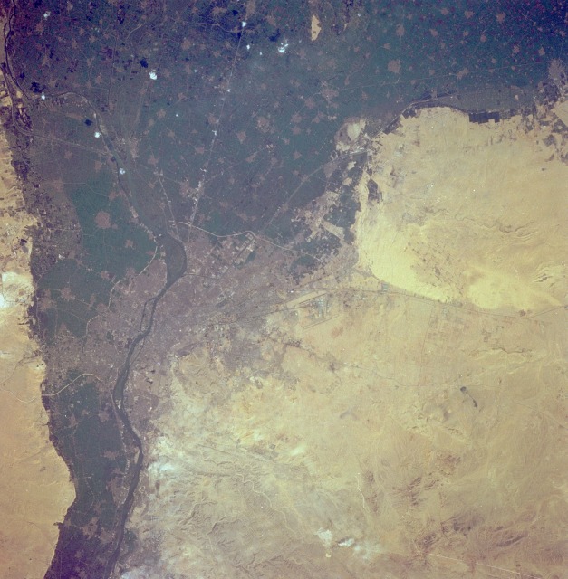 |
| STS062-108-58 Close-up of Cairo, pyramids March 1994 Cairo, the capital of Egypt, is visible near the center of the photograph. Cairo is the largest city in Africa, with almost 10 million people in the greater metropolitan area, and is located at the southern apex (east side) of the Nile River. Roads and railroads radiate from central Cairo. Giza, the third largest city in Egypt, with more than 1 million people, is located along the west bank of the Nile directly across from Cairo. The dark green areas are the intensively cultivated, irrigated agricultural lands along the Nile River and on the fan-shaped Nile River Delta. The grayish areas show the locations of numerous towns and cities on the delta or on the floodplain where there is less vegetation. Cairo International Airport is barely visible northeast of the city. The desert area southeast of Cairo is part of the Arabian Desert, which extends southward along the western edge of the Gulf of Suez. |
| Images: | All Available Images Low-Resolution 126k |
|
| Mission: | STS062 |
|
| Roll - Frame: | 108 - 58 |
|
| Geographical Name: | EGYPT |
|
| Features: | CAIRO, NILE RIVER, AGRICULTURE |
|
| Center Lat x Lon: | 30.0N x 31.5E |
|
| Film Exposure: | N | N=Normal exposure, U=Under exposed, O=Over exposed, F=out of Focus |
| Percentage of Cloud Cover-CLDP: | 0 |
|
| Camera:: | HB |
|
| Camera Tilt: | 29 | LO=Low Oblique, HO=High Oblique, NV=Near Vertical |
| Camera Focal Length: | 250 |
|
| Nadir to Photo Center Direction: | E | The direction from the nadir to the center point, N=North, S=South, E=East, W=West |
| Stereo?: | N | Y=Yes there is an adjacent picture of the same area, N=No there isn't |
| Orbit Number: | 156 |
|
| Date: | 19940314 | YYYYMMDD |
| Time: | 074908 | GMT HHMMSS |
| Nadir Lat: | 30.1N |
Latitude of suborbital point of spacecraft |
| Nadir Lon: | 30.2E |
Longitude of suborbital point of spacecraft |
| Sun Azimuth: | 128 | Clockwise angle in degrees from north to the sun measured at the nadir point |
| Space Craft Altitude: | 141 | nautical miles |
| Sun Elevation: | 43 | Angle in degrees between the horizon and the sun, measured at the nadir point |
| Land Views: | DESERT, PLAIN, VALLEY |
|
| Water Views: | RIVER, DELTA |
|
| Atmosphere Views: | |
|
| Man Made Views: | URBAN AREA, AIRPORT, AGRICULTURE |
|
| City Views: | |
|
Photo is not associated with any sequences | ||
| NASA Home Page |
JSC Home Page |
JSC Digital Image Collection |
Earth Science & Remote Sensing |
|
This service is provided by the International Space Station program and the JSC Earth Science & Remote Sensing Unit, ARES Division, Exploration Integration Science Directorate.

|