
Geographic Region: AUSTRALIA-V
Feature: BURN SCARS, L. HINDMARSH
|
Geographic Region: AUSTRALIA-V Feature: BURN SCARS, L. HINDMARSH |
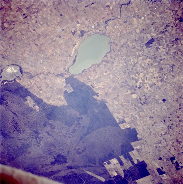 |
| STS062-106-42 Lake Hindmarsh, Victoria, Australia March 1994 Three features--lakes, sand ridges, and agricultural field patterns--characterize this near-vertical photograph of western Victoria Province in southeastern Australia, which is part of the Wimmera internal drainage system. Large Hindmarsh Lake and smaller, dry Lake Albacutya are part of the Wimmera River system that flows northward toward the interior, one of many drainage basins that cover the periphery of the continent. A narrow, meandering ribbon of vegetated river bottom connects these lakes. Northwest of these lakes is an extensive area of sand ridges with some rugged topography visible within the darker, vegetated areas of the sandhills, whose average height is 16 feet (5 meters). The lighter gray shades in the sandhills pinpoint specific areas where fires (usually caused by lightening strikes) have burned the vegetation; lighter fire scars indicate more recent occurrences. Many pasturelands and large cultivated fields, most of which are used for raising sheep and growing commercial grains, are obvious throughout the photograph, except in the northwest quadrant. This view of southern Australia about 100 miles northwest of Melbourne shows areas of protected reserves of natural forests in the midst of agricultural crop lands. The green patch seen here has been recently burned as indicated by the irregular large scar. The impact of winds on the scar is clearly visible. Brushland and agriculture in western New South Wales, west of Swan Hill. Lake Hindmarsh contains water; Lake Albacutya does not. Despite regrowth, fire scars within the uncleared brushland allow the underlying pattern of ancient sand dunes to be discerned. |
| Images: | All Available Images Low-Resolution 149k |
|
| Mission: | STS062 |
|
| Roll - Frame: | 106 - 42 |
|
| Geographical Name: | AUSTRALIA-V |
|
| Features: | BURN SCARS, L. HINDMARSH |
|
| Center Lat x Lon: | 36S x 141.5E |
|
| Film Exposure: | N | N=Normal exposure, U=Under exposed, O=Over exposed, F=out of Focus |
| Percentage of Cloud Cover-CLDP: | 0 |
|
| Camera:: | HB |
|
| Camera Tilt: | 34 | LO=Low Oblique, HO=High Oblique, NV=Near Vertical |
| Camera Focal Length: | 250 |
|
| Nadir to Photo Center Direction: | NW | The direction from the nadir to the center point, N=North, S=South, E=East, W=West |
| Stereo?: | N | Y=Yes there is an adjacent picture of the same area, N=No there isn't |
| Orbit Number: | 203 |
|
| Date: | 19940317 | YYYYMMDD |
| Time: | 062055 | GMT HHMMSS |
| Nadir Lat: | 37S |
Latitude of suborbital point of spacecraft |
| Nadir Lon: | 142.7E |
Longitude of suborbital point of spacecraft |
| Sun Azimuth: | 291 | Clockwise angle in degrees from north to the sun measured at the nadir point |
| Space Craft Altitude: | 138 | nautical miles |
| Sun Elevation: | 28 | Angle in degrees between the horizon and the sun, measured at the nadir point |
| Land Views: | PLAIN, HILL |
|
| Water Views: | |
|
| Atmosphere Views: | |
|
| Man Made Views: | AGRICULTURE |
|
| City Views: | |
|
Photo is not associated with any sequences | ||
| NASA Home Page |
JSC Home Page |
JSC Digital Image Collection |
Earth Science & Remote Sensing |
|
This service is provided by the International Space Station program and the JSC Earth Science & Remote Sensing Unit, ARES Division, Exploration Integration Science Directorate.

|