
Geographic Region: USA-VIRGINIA
Feature: APPALACHIANS,HARRISONBUR
|
Geographic Region: USA-VIRGINIA Feature: APPALACHIANS,HARRISONBUR |
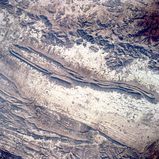 |
| STS062-104-029 Appalachian Mountains, Shenandoah Valley, Virginia, U.S.A. March 1994 Snow covers the valleys and lower ridges of the Appalachian Mountains in this near-nadir view. The city of Harrisonburg is barely visible as a dark smudge in the valley midway between the lower right and right center of the image. The Blue Ridge Mountains extend from the upper left (northeast) to near center right(southwest) of the image. Snow covers the agricultural fields of the Shenandoah River Valley; the meandering river contrasts with the snow at bottom center. Shenandoah National Park, a popular East Coast recreational destination, is in the heavily forested Blue Ridge Mountains. The linear ridges of the Allegheny Mountains in the state of West Virginia are visible at lower left of the image. Maximum elevations for some peaks in this area exceed 4,000 feet (1,220 meters). |
| Images: | All Available Images Low-Resolution 433k |
|
| Mission: | STS062 |
|
| Roll - Frame: | 104 - 29 |
|
| Geographical Name: | USA-VIRGINIA |
|
| Features: | APPALACHIANS,HARRISONBUR |
|
| Center Lat x Lon: | 38.5N x 78.5W |
|
| Film Exposure: | N | N=Normal exposure, U=Under exposed, O=Over exposed, F=out of Focus |
| Percentage of Cloud Cover-CLDP: | 0 |
|
| Camera:: | HB |
|
| Camera Tilt: | 25 | LO=Low Oblique, HO=High Oblique, NV=Near Vertical |
| Camera Focal Length: | 250 |
|
| Nadir to Photo Center Direction: | NE | The direction from the nadir to the center point, N=North, S=South, E=East, W=West |
| Stereo?: | Y | Y=Yes there is an adjacent picture of the same area, N=No there isn't |
| Orbit Number: | 49 |
|
| Date: | 19940307 | YYYYMMDD |
| Time: | 142406 | GMT HHMMSS |
| Nadir Lat: | 37.9N |
Latitude of suborbital point of spacecraft |
| Nadir Lon: | 79.6W |
Longitude of suborbital point of spacecraft |
| Sun Azimuth: | 124 | Clockwise angle in degrees from north to the sun measured at the nadir point |
| Space Craft Altitude: | 161 | nautical miles |
| Sun Elevation: | 29 | Angle in degrees between the horizon and the sun, measured at the nadir point |
| Land Views: | MOUNTAIN, VALLEY, FOREST, FAULT |
|
| Water Views: | |
|
| Atmosphere Views: | |
|
| Man Made Views: | |
|
| City Views: | |
|
Photo is not associated with any sequences | ||
| NASA Home Page |
JSC Home Page |
JSC Digital Image Collection |
Earth Science & Remote Sensing |
|
This service is provided by the International Space Station program and the JSC Earth Science & Remote Sensing Unit, ARES Division, Exploration Integration Science Directorate.

|