
Geographic Region: USA-VIRGINIA
Feature: APPALACHIAN MTS.
|
Geographic Region: USA-VIRGINIA Feature: APPALACHIAN MTS. |
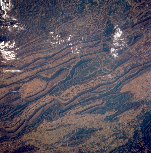 |
| STS062-104-026 Appalachian Mountains, Virginia,U.S.A. March 1994 The Appalachian Mountains of southwestern Virginia can be seen in this near-nadir view. The principal mountains of the eastern United States roughly parallels the Atlantic Coast, and are a narrow system rarely exceeding a width of 100 miles (160 kilometers). The Appalachians are ecologically unique because of their extensive forests of mixed hardwoods and softwoods. The area shown in this image is to the west-southwest of Roanoke, Virginia. Some of the elevations of the peaks exceed 4,000 feet (1,220 meters). The valleys interspersed between the linear mountains have good soils for agriculture. The rough terrain of the Cumberland Mountains, or Cumberland Plateau can be seen covering the bottom portion of the image. |
| Images: | All Available Images Low-Resolution 397k |
|
| Mission: | STS062 |
|
| Roll - Frame: | 104 - 26 |
|
| Geographical Name: | USA-VIRGINIA |
|
| Features: | APPALACHIAN MTS. |
|
| Center Lat x Lon: | 37.0N x 81W |
|
| Film Exposure: | N | N=Normal exposure, U=Under exposed, O=Over exposed, F=out of Focus |
| Percentage of Cloud Cover-CLDP: | 15 |
|
| Camera:: | HB |
|
| Camera Tilt: | 27 | LO=Low Oblique, HO=High Oblique, NV=Near Vertical |
| Camera Focal Length: | 250 |
|
| Nadir to Photo Center Direction: | E | The direction from the nadir to the center point, N=North, S=South, E=East, W=West |
| Stereo?: | Y | Y=Yes there is an adjacent picture of the same area, N=No there isn't |
| Orbit Number: | 49 |
|
| Date: | 19940307 | YYYYMMDD |
| Time: | 142331 | GMT HHMMSS |
| Nadir Lat: | 37.4N |
Latitude of suborbital point of spacecraft |
| Nadir Lon: | 82.3W |
Longitude of suborbital point of spacecraft |
| Sun Azimuth: | 122 | Clockwise angle in degrees from north to the sun measured at the nadir point |
| Space Craft Altitude: | 161 | nautical miles |
| Sun Elevation: | 28 | Angle in degrees between the horizon and the sun, measured at the nadir point |
| Land Views: | MOUNTAIN, VALLEY, PLATEAU, FAULT, FOREST |
|
| Water Views: | |
|
| Atmosphere Views: | |
|
| Man Made Views: | AGRICULTURE |
|
| City Views: | |
|
Photo is not associated with any sequences | ||
| NASA Home Page |
JSC Home Page |
JSC Digital Image Collection |
Earth Science & Remote Sensing |
|
This service is provided by the International Space Station program and the JSC Earth Science & Remote Sensing Unit, ARES Division, Exploration Integration Science Directorate.

|