
Geographic Region: USA-DC
Feature: WASHINGTON DC, SNOW LINE
|
Geographic Region: USA-DC Feature: WASHINGTON DC, SNOW LINE |
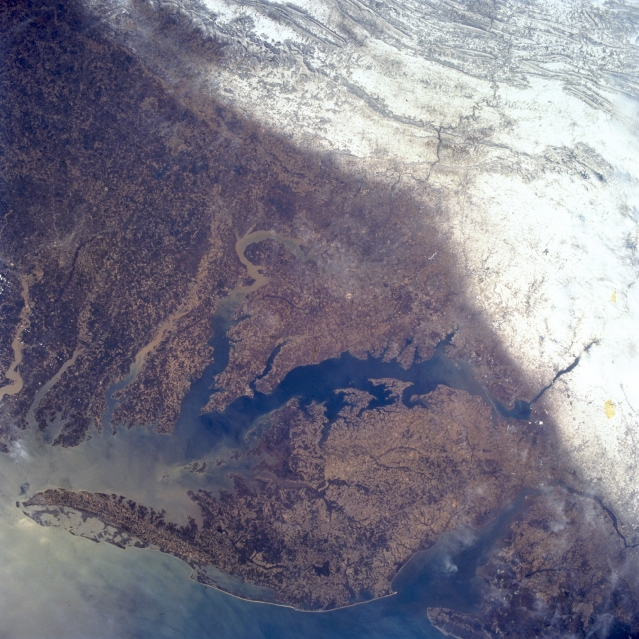 |
| STS062-102-007 Appalachian Mountains; Chesapeake Bay; Delmarva Peninsula, U.S.A. March 1994 This panoramic southwest-looking view delineates between the white snow covered ridges and valleys of the Appalachian Mountains to the topographically lower Piedmont and coastal plains. The 180 mile (290 km) long Delmarva Peninsula is visible in the lower portion of the image. Immediately to the peninsula's west (between the Delmarva Peninsula and the mainland) is the 200 mile (320 km) long Chesapeake Bay. Numerous sediment-laden rivers, including the Patuxent, Potomac, Rappahannock, York, and James, can be seen flowing into Chesapeake Bay. Near the bottom right of the image is Delaware Bay. |
| Images: | All Available Images Low-Resolution 355k |
|
| Mission: | STS062 |
|
| Roll - Frame: | 102 - 7 |
|
| Geographical Name: | USA-DC |
|
| Features: | WASHINGTON DC, SNOW LINE |
|
| Center Lat x Lon: | 39.0N x 77W |
|
| Film Exposure: | N | N=Normal exposure, U=Under exposed, O=Over exposed, F=out of Focus |
| Percentage of Cloud Cover-CLDP: | 5 |
|
| Camera:: | HB |
|
| Camera Tilt: | 5 | LO=Low Oblique, HO=High Oblique, NV=Near Vertical |
| Camera Focal Length: | 40 |
|
| Nadir to Photo Center Direction: | N | The direction from the nadir to the center point, N=North, S=South, E=East, W=West |
| Stereo?: | Y | Y=Yes there is an adjacent picture of the same area, N=No there isn't |
| Orbit Number: | 50 |
|
| Date: | 19940307 | YYYYMMDD |
| Time: | 155949 | GMT HHMMSS |
| Nadir Lat: | 38.8N |
Latitude of suborbital point of spacecraft |
| Nadir Lon: | 76.9W |
Longitude of suborbital point of spacecraft |
| Sun Azimuth: | 153 | Clockwise angle in degrees from north to the sun measured at the nadir point |
| Space Craft Altitude: | 161 | nautical miles |
| Sun Elevation: | 43 | Angle in degrees between the horizon and the sun, measured at the nadir point |
| Land Views: | MOUNTAIN, PLAIN |
|
| Water Views: | BAY, ESTUARY, OCEAN, RIVER |
|
| Atmosphere Views: | |
|
| Man Made Views: | |
|
| City Views: | |
|
Photo is not associated with any sequences | ||
| NASA Home Page |
JSC Home Page |
JSC Digital Image Collection |
Earth Science & Remote Sensing |
|
This service is provided by the International Space Station program and the JSC Earth Science & Remote Sensing Unit, ARES Division, Exploration Integration Science Directorate.

|