
Geographic Region: USA-FLORIDA
Feature: PANAMA CITY
|
Geographic Region: USA-FLORIDA Feature: PANAMA CITY |
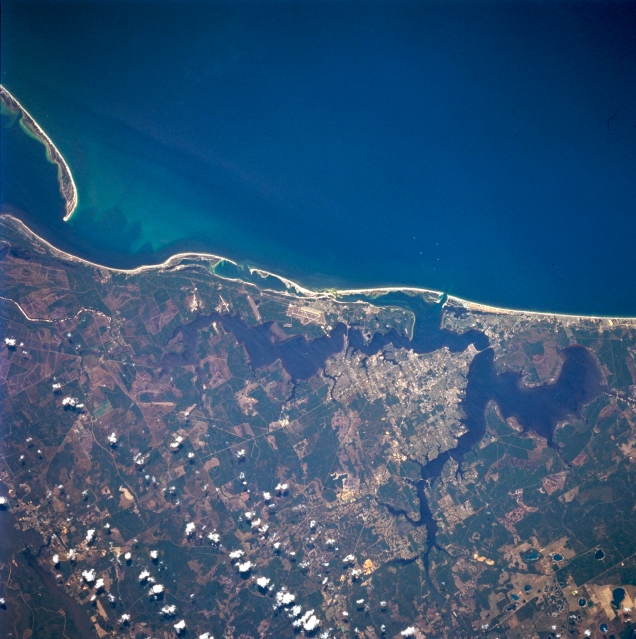 |
| STS062-102-194 Panama City, Florida, U.S.A. March 1994 Highly reflective Panama City (near center) is connected to the coastal peninsula both east and west of dark Saint Andrew Bay (East Bay and West Bay), which is southwest of the city and has a channel connecting with the Gulf of Mexico. Discernible are broad, sandy beaches; highly reflective Tyndall Air Force Base east of the bay; and the northern end of Saint Joseph Bay sand spit (upper left corner). Several landscapes are apparent--darker, undisturbed vegetation; lighter cultivated field patterns and areas that are being developed; and swampy areas along the coast. |
| Images: | All Available Images Low-Resolution 335k |
|
| Mission: | STS062 |
|
| Roll - Frame: | 102 - 194 |
|
| Geographical Name: | USA-FLORIDA |
|
| Features: | PANAMA CITY |
|
| Center Lat x Lon: | 30.0N x 85.5W |
|
| Film Exposure: | N | N=Normal exposure, U=Under exposed, O=Over exposed, F=out of Focus |
| Percentage of Cloud Cover-CLDP: | 5 |
|
| Camera:: | HB |
|
| Camera Tilt: | 17 | LO=Low Oblique, HO=High Oblique, NV=Near Vertical |
| Camera Focal Length: | 250 |
|
| Nadir to Photo Center Direction: | W | The direction from the nadir to the center point, N=North, S=South, E=East, W=West |
| Stereo?: | Y | Y=Yes there is an adjacent picture of the same area, N=No there isn't |
| Orbit Number: | 83 |
|
| Date: | 19940309 | YYYYMMDD |
| Time: | 175053 | GMT HHMMSS |
| Nadir Lat: | 29.8N |
Latitude of suborbital point of spacecraft |
| Nadir Lon: | 84.7W |
Longitude of suborbital point of spacecraft |
| Sun Azimuth: | 181 | Clockwise angle in degrees from north to the sun measured at the nadir point |
| Space Craft Altitude: | 162 | nautical miles |
| Sun Elevation: | 56 | Angle in degrees between the horizon and the sun, measured at the nadir point |
| Land Views: | COAST, PLAIN |
|
| Water Views: | BAY, GULF, SWAMP |
|
| Atmosphere Views: | |
|
| Man Made Views: | HIGHWAY, AIRPORT |
|
| City Views: | |
|
Photo is not associated with any sequences | ||
| NASA Home Page |
JSC Home Page |
JSC Digital Image Collection |
Earth Science & Remote Sensing |
|
This service is provided by the International Space Station program and the JSC Earth Science & Remote Sensing Unit, ARES Division, Exploration Integration Science Directorate.

|