
Geographic Region: AUSTRALIA-SA
Feature: L. TORRENS, MT. RANGE
|
Geographic Region: AUSTRALIA-SA Feature: L. TORRENS, MT. RANGE |
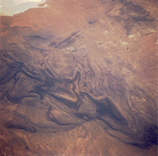 |
| STS062-101-033 Flinders Range, South Australia, Australia March 1994 The northern end of the Flinders Ranges in South Australia show up in dramatic fashion (darker and more textured-looking features), highlighting the oldest and most rugged mountains in Australia. This chain of mountains is mostly made up of sedimentary rock with steep ridges and deep gorges. Several elevations in this section of the Flinders Ranges exceed 3000 feet (915 meters) above sea level. The landscape has a rich heritage of mining activities that have included copper, silver, gold, and coal. These ranges have also provided a favorable environment for farmers, pastoralists (sheep), and the Aboriginal peoples. The small "white" spot (slightly above and left of center) is where Leigh Creek, an oasis in an otherwise arid setting, is located. This town is known for the mining of a brown coal. A small section of the northeast shoreline of dry lake, Lake Torrens (light colored feature), is visible in the upper left corner of the picture. A barely discernible string of dry lakes can be traced to the north from the Leigh Creek area. |
| Images: | All Available Images Low-Resolution 319k |
|
| Mission: | STS062 |
|
| Roll - Frame: | 101 - 33 |
|
| Geographical Name: | AUSTRALIA-SA |
|
| Features: | L. TORRENS, MT. RANGE |
|
| Center Lat x Lon: | 30.5S x 139.0E |
|
| Film Exposure: | N | N=Normal exposure, U=Under exposed, O=Over exposed, F=out of Focus |
| Percentage of Cloud Cover-CLDP: | 0 |
|
| Camera:: | HB |
|
| Camera Tilt: | 54 | LO=Low Oblique, HO=High Oblique, NV=Near Vertical |
| Camera Focal Length: | 250 |
|
| Nadir to Photo Center Direction: | NW | The direction from the nadir to the center point, N=North, S=South, E=East, W=West |
| Stereo?: | N | Y=Yes there is an adjacent picture of the same area, N=No there isn't |
| Orbit Number: | 155 |
|
| Date: | 19940314 | YYYYMMDD |
| Time: | 064638 | GMT HHMMSS |
| Nadir Lat: | 32.2S |
Latitude of suborbital point of spacecraft |
| Nadir Lon: | 142.3E |
Longitude of suborbital point of spacecraft |
| Sun Azimuth: | 284 | Clockwise angle in degrees from north to the sun measured at the nadir point |
| Space Craft Altitude: | 163 | nautical miles |
| Sun Elevation: | 25 | Angle in degrees between the horizon and the sun, measured at the nadir point |
| Land Views: | MOUNTAIN |
|
| Water Views: | PLAYA |
|
| Atmosphere Views: | |
|
| Man Made Views: | |
|
| City Views: | |
|
Photo is not associated with any sequences | ||
| NASA Home Page |
JSC Home Page |
JSC Digital Image Collection |
Earth Science & Remote Sensing |
|
This service is provided by the International Space Station program and the JSC Earth Science & Remote Sensing Unit, ARES Division, Exploration Integration Science Directorate.

|