
Geographic Region: AUSTRALIA-WA
Feature: PAN-SHARK B.,DARLING RA.
|
Geographic Region: AUSTRALIA-WA Feature: PAN-SHARK B.,DARLING RA. |
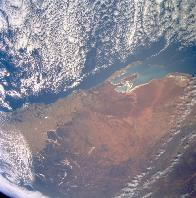 |
| STS061-83-15 Shark Bay Area, Western Australia, Australia December 1993 Even though clouds obscure part of this picture, the synoptic scale provides a southeast-looking view of west central Western Australia. Shark Bay, the large divided embayment, is visible in the foreground. The entire subregion of the Geraldton Sandplains (the region with the uniform reddish color) can be seen south of Shark Bay. The linear patterns marking boundaries between lighter and darker regions show the extent of human ownership and intrusion into a more rugged and dry landscape in the semiarid region of Western Australia. The very light features that seem to follow valley contours in the undeveloped Bush landscape are a series of dry lakes (highly reflective surfaces, not to be confused with cloud patterns). Cleared fields of the western wheat belt and the outback inland. Nice land-breeze effect on the cumulus cloud field. |
| Images: | All Available Images Low-Resolution 153k |
|
| Mission: | STS061 |
|
| Roll - Frame: | 83 - 15 |
|
| Geographical Name: | AUSTRALIA-WA |
|
| Features: | PAN-SHARK B.,DARLING RA. |
|
| Center Lat x Lon: | 27S x 115.0E |
|
| Film Exposure: | N | N=Normal exposure, U=Under exposed, O=Over exposed, F=out of Focus |
| Percentage of Cloud Cover-CLDP: | 30 |
|
| Camera:: | HB |
|
| Camera Tilt: | HO | LO=Low Oblique, HO=High Oblique, NV=Near Vertical |
| Camera Focal Length: | 100 |
|
| Nadir to Photo Center Direction: | The direction from the nadir to the center point, N=North, S=South, E=East, W=West |
|
| Stereo?: | N | Y=Yes there is an adjacent picture of the same area, N=No there isn't |
| Orbit Number: | |
|
| Date: | 19931213 | YYYYMMDD |
| Time: | GMT HHMMSS |
|
| Nadir Lat: | N |
Latitude of suborbital point of spacecraft |
| Nadir Lon: | E |
Longitude of suborbital point of spacecraft |
| Sun Azimuth: | Clockwise angle in degrees from north to the sun measured at the nadir point |
|
| Space Craft Altitude: | nautical miles |
|
| Sun Elevation: | Angle in degrees between the horizon and the sun, measured at the nadir point |
|
| Land Views: | DESERT, DUNE, COAST |
|
| Water Views: | BAY |
|
| Atmosphere Views: | |
|
| Man Made Views: | |
|
| City Views: | |
|
Photo is not associated with any sequences | ||
| NASA Home Page |
JSC Home Page |
JSC Digital Image Collection |
Earth Science & Remote Sensing |
|
This service is provided by the International Space Station program and the JSC Earth Science & Remote Sensing Unit, ARES Division, Exploration Integration Science Directorate.

|