
Geographic Region: DOMINICAN REPUBLIC
Feature: HISPANIOLA, HUBBLE
|
Geographic Region: DOMINICAN REPUBLIC Feature: HISPANIOLA, HUBBLE |
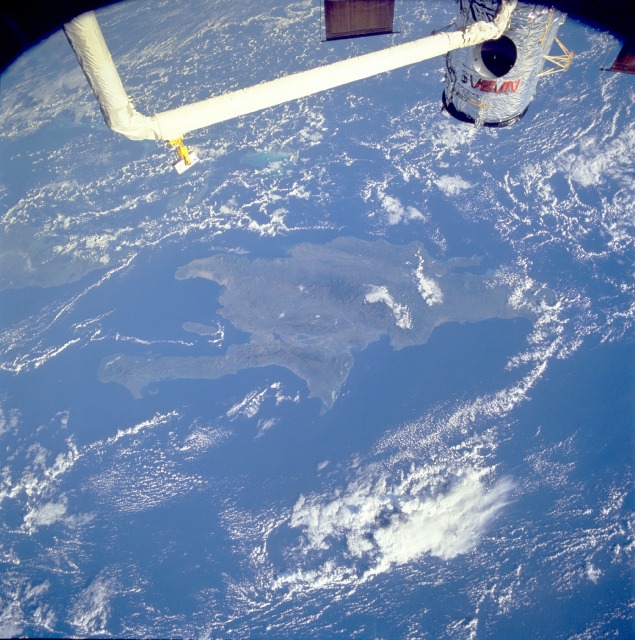 |
| STS061-079-081 Hispaniola (Isla de Santo Domingo), Greater Antilles December 1993 This low-oblique, north-looking photograph provides an excellent view of Hispaniola--discovered by Christopher Columbus in 1492--the second-largest island in the West Indies. Situated between Cuba and Puerto Rico (to the west and east, respectively) and the Atlantic Ocean and the Caribbean Sea (to the north and south, respectively), Hispaniola covers 29 530 square miles (76 480 square kilometers). Two main features of this mountainous terrain are the Cordillera Central, the backbone of Hispaniola, and the Enriquillo, a cul-de-sac depression. The Cordillera Central, formed from a checkered array of volcanic, metamorphic, and sedimentary rocks, presents a maze of peaks and ridges with flat-bottomed intermontane valleys. Its highest peak rises 10 417 feet (3177 meters) in the east-central part of the island. The Enriquillo, a rift valley that was once a maritime strait, has some interior dry surface below sea level that is covered by large salt lakes such as Lago de Enriquillo and Etang-Saumâtre. The first New World settlement was established in 1493 near the modern city of Cap-Haïtien, Haiti, on the north coast. With the island's subtropical climate and abundant year-round rainfall, agriculture (coffee, cocoa, and sugarcane) flourishes. |
| Images: | All Available Images Low-Resolution 152k |
|
| Mission: | STS061 |
|
| Roll - Frame: | 79 - 81 |
|
| Geographical Name: | DOMINICAN REPUBLIC |
|
| Features: | HISPANIOLA, HUBBLE |
|
| Center Lat x Lon: | 18.5N x 71.5W |
|
| Film Exposure: | N | N=Normal exposure, U=Under exposed, O=Over exposed, F=out of Focus |
| Percentage of Cloud Cover-CLDP: | 40 |
|
| Camera:: | HB |
|
| Camera Tilt: | 23 | LO=Low Oblique, HO=High Oblique, NV=Near Vertical |
| Camera Focal Length: | 40 |
|
| Nadir to Photo Center Direction: | N | The direction from the nadir to the center point, N=North, S=South, E=East, W=West |
| Stereo?: | Y | Y=Yes there is an adjacent picture of the same area, N=No there isn't |
| Orbit Number: | 33 |
|
| Date: | 19931204 | YYYYMMDD |
| Time: | 124606 | GMT HHMMSS |
| Nadir Lat: | 16.3N |
Latitude of suborbital point of spacecraft |
| Nadir Lon: | 71.1W |
Longitude of suborbital point of spacecraft |
| Sun Azimuth: | 123 | Clockwise angle in degrees from north to the sun measured at the nadir point |
| Space Craft Altitude: | 316 | nautical miles |
| Sun Elevation: | 22 | Angle in degrees between the horizon and the sun, measured at the nadir point |
| Land Views: | ISLAND, MOUNTAIN, RIFT, FAULT |
|
| Water Views: | GULF, SEA, OCEAN, CHANNEL |
|
| Atmosphere Views: | |
|
| Man Made Views: | |
|
| City Views: | |
|
Photo is not associated with any sequences | ||
| NASA Home Page |
JSC Home Page |
JSC Digital Image Collection |
Earth Science & Remote Sensing |
|
This service is provided by the International Space Station program and the JSC Earth Science & Remote Sensing Unit, ARES Division, Exploration Integration Science Directorate.

|