Geographic Region: MALAWI
Feature: L. NYASA, SMOKE, RIVER
|
Geographic Region: MALAWI Feature: L. NYASA, SMOKE, RIVER |
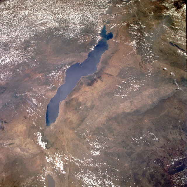 |
| STS061-075-048 Lake Malawi (Lake Nyasa), Malawi December 1993 This low-oblique, southeast-looking photograph shows Lake Malawi, one of many elongated lakes that form part of the Great Rift Valley of east Africa. The lake, bounded by steep mountains on all sides except the southern end, is approximately 360 miles (580 kilometers) long, averages 25 miles (40 kilometers) in width, and has a maximum depth of 2316 feet (706 meters). Lake Malawi is drained at the south end by the Shire River, which eventually empties into the Zambezi River. The lake and its steep-sloped shoreline were created by faulting that caused a thrust upward as the valley floor subsided between the slopes. The darker area along the northwest coast of the lake is the Nyika Plateau, which has several elevations more than 8000 feet (2440 meters) above sea level. Landlocked Malawi extends along the entire west coast of the lake. The large Luangwa River basin is visible as it drains to the southwest. Immediately west of the Luangwa River Valley stand the northeast-southwest-trending Muchinga Mountains with their dark ridgeline and maximum elevations reaching 6000 feet (1830 meters) above sea level. Northwest of this mountain range, drainage is to the north and west into the much larger Zaire (Congo) River watershed. |
| Images: | All Available Images Low-Resolution 168k |
|
| Mission: | STS061 |
|
| Roll - Frame: | 75 - 48 |
|
| Geographical Name: | MALAWI |
|
| Features: | L. NYASA, SMOKE, RIVER |
|
| Center Lat x Lon: | 12S x 34.0E |
|
| Film Exposure: | N | N=Normal exposure, U=Under exposed, O=Over exposed, F=out of Focus |
| Percentage of Cloud Cover-CLDP: | 35 |
|
| Camera:: | HB |
|
| Camera Tilt: | 25 | LO=Low Oblique, HO=High Oblique, NV=Near Vertical |
| Camera Focal Length: | 40 |
|
| Nadir to Photo Center Direction: | SE | The direction from the nadir to the center point, N=North, S=South, E=East, W=West |
| Stereo?: | Y | Y=Yes there is an adjacent picture of the same area, N=No there isn't |
| Orbit Number: | 16 |
|
| Date: | 19931203 | YYYYMMDD |
| Time: | 094931 | GMT HHMMSS |
| Nadir Lat: | 10S |
Latitude of suborbital point of spacecraft |
| Nadir Lon: | 32.7E |
Longitude of suborbital point of spacecraft |
| Sun Azimuth: | 191 | Clockwise angle in degrees from north to the sun measured at the nadir point |
| Space Craft Altitude: | 304 | nautical miles |
| Sun Elevation: | 78 | Angle in degrees between the horizon and the sun, measured at the nadir point |
| Land Views: | MOUNTAIN, VALLEY, PLATEAU, FOREST |
|
| Water Views: | LAKE, RIVER |
|
| Atmosphere Views: | |
|
| Man Made Views: | |
|
| City Views: | |
|
Photo is not associated with any sequences | ||
| NASA Home Page |
JSC Home Page |
JSC Digital Image Collection |
Earth Science & Remote Sensing |
|
This service is provided by the International Space Station program and the JSC Earth Science & Remote Sensing Unit, ARES Division, Exploration Integration Science Directorate.

|