Geographic Region: NIGERIA
Feature: L. CHAD, RIVER, DESERT
|
Geographic Region: NIGERIA Feature: L. CHAD, RIVER, DESERT |
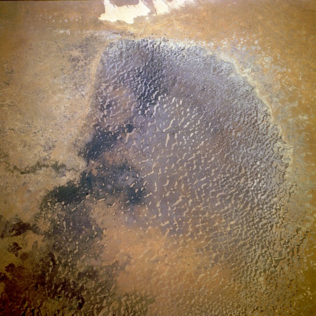 |
| STS061-075-023 Lake Chad (North Basin), Chad December 1993 The north basin of Lake Chad shows little evidence of vegetation. Agriculture occurs in a few fragmented areas, primarily in the lowland dunes. This photograph shows water conditions that have prevailed in the north basin during the decades of 1980s and 1990s. The last major documentation of substantial water in the north basin was obtained when Apollo astronauts collected photographs of this lake in the late 1960s. The light tan areas northwest of the basin are classified as salty, dry lakebeds. Most of the moisture that reaches the north basin is provided by intermittently flowing rivers that enter the lake from the west-southwest. (Refer to photograph STS-061-075-022 to see extensive vegetation and standing water in the south basin.) |
| Images: | All Available Images Low-Resolution 155k |
|
| Mission: | STS061 |
|
| Roll - Frame: | 75 - 23 |
|
| Geographical Name: | NIGERIA |
|
| Features: | L. CHAD, RIVER, DESERT |
|
| Center Lat x Lon: | 14.0N x 13.5E |
|
| Film Exposure: | N | N=Normal exposure, U=Under exposed, O=Over exposed, F=out of Focus |
| Percentage of Cloud Cover-CLDP: | 0 |
|
| Camera:: | HB |
|
| Camera Tilt: | 22 | LO=Low Oblique, HO=High Oblique, NV=Near Vertical |
| Camera Focal Length: | 40 |
|
| Nadir to Photo Center Direction: | W | The direction from the nadir to the center point, N=North, S=South, E=East, W=West |
| Stereo?: | Y | Y=Yes there is an adjacent picture of the same area, N=No there isn't |
| Orbit Number: | 15 |
|
| Date: | 19931203 | YYYYMMDD |
| Time: | 080052 | GMT HHMMSS |
| Nadir Lat: | 13.6N |
Latitude of suborbital point of spacecraft |
| Nadir Lon: | 15.4E |
Longitude of suborbital point of spacecraft |
| Sun Azimuth: | 130 | Clockwise angle in degrees from north to the sun measured at the nadir point |
| Space Craft Altitude: | 290 | nautical miles |
| Sun Elevation: | 36 | Angle in degrees between the horizon and the sun, measured at the nadir point |
| Land Views: | BASIN, DESERT, DUNE |
|
| Water Views: | LAKE, RIVER, DELTA |
|
| Atmosphere Views: | |
|
| Man Made Views: | |
|
| City Views: | |
|
Associated Photos in Sequence:  Photo #: AS07-8-1932 Photo #: AS07-8-1932Description: AFRICA, LAKE CHAD-1968--LAKE LEVELS BEFORE BEGINNING OF DROUGHT, 1970 Sequence ID: 3A  Photo #: STS052-99-9 Photo #: STS052-99-9Description: AFRICA, LAKE CHAD-1992--LAKE LEVELS FROM DROUGHT THAT BEGAN IN 1970 Sequence ID: 3B  Photo #: STS052-80-66 Photo #: STS052-80-66Description: AFRICA, LAKE CHAD-1992--LAKE LEVELS FROM DROUGHT THAT BEGAN IN 1970 Sequence ID: 3C  Photo #: STS061-75-22 Photo #: STS061-75-22Description: AFRICA, LAKE CHAD-1993--LAKE LEVELS FROM DROUGHT THAT BEGAN IN 1970 Sequence ID: 3D  Photo #: STS061-75-23 ** Currently displayed photo ** Photo #: STS061-75-23 ** Currently displayed photo ** Description: AFRICA, LAKE CHAD-1993--LAKE LEVELS FROM DROUGHT THAT BEGAN IN 1970 Sequence ID: 3E | ||
| NASA Home Page |
JSC Home Page |
JSC Digital Image Collection |
Earth Science & Remote Sensing |
|
This service is provided by the International Space Station program and the JSC Earth Science & Remote Sensing Unit, ARES Division, Exploration Integration Science Directorate.

|