
Geographic Region: SAUDI ARABIA
Feature: TUWAYQ PIVOT IRRIGATION
|
Geographic Region: SAUDI ARABIA Feature: TUWAYQ PIVOT IRRIGATION |
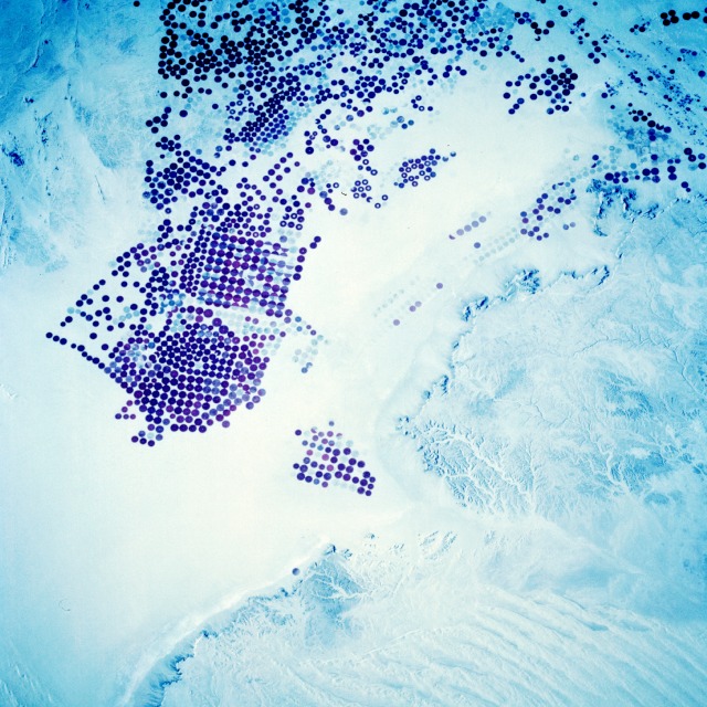 |
| STS060-097-038 Pivot Irrigation, Saudi Arabia February 1994 Modern drilling, pumping, and distribution systems have permitted many arid and semiarid regions of the world to become productive farmlands. This infrared photograph of the southwestern end of the Tuwayq Mountains shows one of four areas in Saudi Arabia where center-pivot irrigation has produced a dramatic circle of vegetation in an otherwise barren desert. Specific field sizes vary; however, many circular plots in this photograph measure approximately 0.6 mile (1 kilometer) in diameter. Water (known as fossil water) is extracted from subsurface aquifers of previous, wetter geological periods. Dark circles represent fields where crops are presently grown; faint circles outline field patterns where no crops are being grown. Some fields have been taken out of production to lie fallow, some have been harvested or planted with a new crop, and some have been taken out of production indefinitely. Although many desert regions of the world are now successfully farmed, a finite supply of fossil water exists, and eventually the supply of water will be exhausted. |
| Images: | All Available Images Low-Resolution 151k |
|
| Mission: | STS060 |
|
| Roll - Frame: | 97 - 38 |
|
| Geographical Name: | SAUDI ARABIA |
|
| Features: | TUWAYQ PIVOT IRRIGATION |
|
| Center Lat x Lon: | 20.0N x 45.0E |
|
| Film Exposure: | N | N=Normal exposure, U=Under exposed, O=Over exposed, F=out of Focus |
| Percentage of Cloud Cover-CLDP: | 0 |
|
| Camera:: | HB |
|
| Camera Tilt: | 25 | LO=Low Oblique, HO=High Oblique, NV=Near Vertical |
| Camera Focal Length: | 250 |
|
| Nadir to Photo Center Direction: | NW | The direction from the nadir to the center point, N=North, S=South, E=East, W=West |
| Stereo?: | Y | Y=Yes there is an adjacent picture of the same area, N=No there isn't |
| Orbit Number: | 48 |
|
| Date: | 19940206 | YYYYMMDD |
| Time: | 122903 | GMT HHMMSS |
| Nadir Lat: | 19.0N |
Latitude of suborbital point of spacecraft |
| Nadir Lon: | 46.1E |
Longitude of suborbital point of spacecraft |
| Sun Azimuth: | 238 | Clockwise angle in degrees from north to the sun measured at the nadir point |
| Space Craft Altitude: | 191 | nautical miles |
| Sun Elevation: | 30 | Angle in degrees between the horizon and the sun, measured at the nadir point |
| Land Views: | DESERT, ESCARPMENT, DUNE, HILL |
|
| Water Views: | |
|
| Atmosphere Views: | |
|
| Man Made Views: | AGRICULTURE, PIVOT IRRIGATION |
|
| City Views: | |
|
Associated Photos in Sequence:  Photo #: STS032-96-32 Photo #: STS032-96-32Description: SAUDI ARABIA, NAFUD-1990; CHANGING DESERT PIVOT IRRIGATION PATTERNS Sequence ID: 8A  Photo #: STS060-97-38 ** Currently displayed photo ** Photo #: STS060-97-38 ** Currently displayed photo ** Description: SAUDI ARABIA, NAFUD-1/94; CHANGING DESERT PIVOT IRRIGATION PATTERNS Sequence ID: 8B  Photo #: STS062-110-AA Photo #: STS062-110-AADescription: SAUDI ARABIA, NAFUD-3/94; CHANGING DESERT PIVOT IRRIGATION PATTERNS Sequence ID: 8C | ||
| NASA Home Page |
JSC Home Page |
JSC Digital Image Collection |
Earth Science & Remote Sensing |
|
This service is provided by the International Space Station program and the JSC Earth Science & Remote Sensing Unit, ARES Division, Exploration Integration Science Directorate.

|