
Geographic Region: CANADA-Q
Feature: MONTREAL, ST. LAWRENCE R
|
Geographic Region: CANADA-Q Feature: MONTREAL, ST. LAWRENCE R |
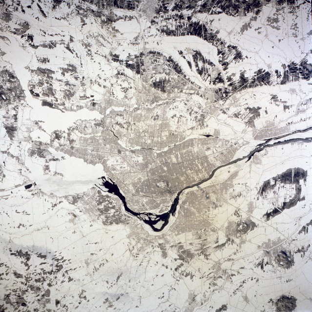 |
| STS060-094-071 Montreal, Quebec, Canada February 1994 The snow covering helps accentuate several major features of metropolitan Montreal, Canada's second largest city with slightly more than 3 000 000 people. The Saint Lawrence River stands out as it flows northeast through the south and northeast parts of the city. Most of the darker areas scattered randomly throughout the photograph are forests. The main part of the city is located on two islands--Montreal Island (the larger and southern island) and Jesus Island (north of Montreal Island). The downtown area is located north of the Saint Lawrence Seaway near the center of Montreal Island. The oval shape north of the central business district is Mount Royal Park. Runways of the two major airports--Dorval (Montreal) International, west of downtown, and Mirabel International, located approximately 26 miles (40 kilometers) northwest of downtown--are distinguishable by their long, angular runways. |
| Images: | All Available Images Low-Resolution 191k |
|
| Mission: | STS060 |
|
| Roll - Frame: | 94 - 71 |
|
| Geographical Name: | CANADA-Q |
|
| Features: | MONTREAL, ST. LAWRENCE R |
|
| Center Lat x Lon: | 45.5N x 73.5W |
|
| Film Exposure: | N | N=Normal exposure, U=Under exposed, O=Over exposed, F=out of Focus |
| Percentage of Cloud Cover-CLDP: | 0 |
|
| Camera:: | HB |
|
| Camera Tilt: | 6 | LO=Low Oblique, HO=High Oblique, NV=Near Vertical |
| Camera Focal Length: | 100 |
|
| Nadir to Photo Center Direction: | E | The direction from the nadir to the center point, N=North, S=South, E=East, W=West |
| Stereo?: | Y | Y=Yes there is an adjacent picture of the same area, N=No there isn't |
| Orbit Number: | 114 |
|
| Date: | 19940210 | YYYYMMDD |
| Time: | 170250 | GMT HHMMSS |
| Nadir Lat: | 45.6N |
Latitude of suborbital point of spacecraft |
| Nadir Lon: | 73.8W |
Longitude of suborbital point of spacecraft |
| Sun Azimuth: | 178 | Clockwise angle in degrees from north to the sun measured at the nadir point |
| Space Craft Altitude: | 191 | nautical miles |
| Sun Elevation: | 30 | Angle in degrees between the horizon and the sun, measured at the nadir point |
| Land Views: | ISLAND, HILL, VALLEY |
|
| Water Views: | RIVER, CHANNEL |
|
| Atmosphere Views: | |
|
| Man Made Views: | URBAN AREA, AIRPORT |
|
| City Views: | MONTREAL |
|
Photo is not associated with any sequences | ||
| NASA Home Page |
JSC Home Page |
JSC Digital Image Collection |
Earth Science & Remote Sensing |
|
This service is provided by the International Space Station program and the JSC Earth Science & Remote Sensing Unit, ARES Division, Exploration Integration Science Directorate.

|