
Geographic Region: USA-ARIZONA
Feature: YUMA AREA
|
Geographic Region: USA-ARIZONA Feature: YUMA AREA |
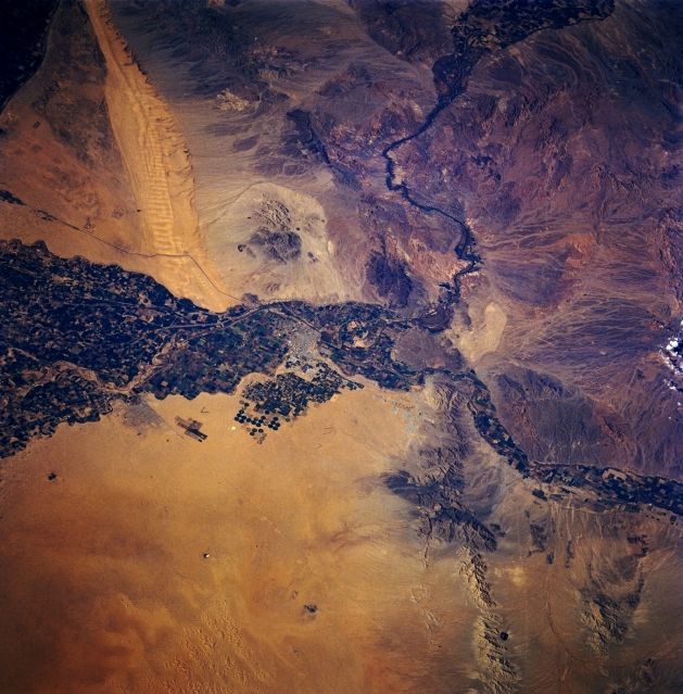 |
| STS060-093-082 Yuma, Arizona, U.S.A. February 1994 This photograph of part of the Sonoran Desert, which includes southeastern California, southwestern Arizona, and a small section of Mexico, shows the great extent of crop irrigation in the floodplains of the Colorado and Gila Rivers. The outline of the small desert city of Yuma and some circular center-pivot irrigated fields to its south are discernible near the center of the photograph. Several natural features are visible--the elongated northwest-southeast-trending Sand Hills in southeast California; the merging east of Yuma of the west-flowing Gila River and the south-flowing Colorado River; and the low, heavily mined Gila Mountains southeast of Yuma. |
| Images: | All Available Images Low-Resolution 367k |
|
| Mission: | STS060 |
|
| Roll - Frame: | 93 - 82 |
|
| Geographical Name: | USA-ARIZONA |
|
| Features: | YUMA AREA |
|
| Center Lat x Lon: | 32.5N x 114.5W |
|
| Film Exposure: | N | N=Normal exposure, U=Under exposed, O=Over exposed, F=out of Focus |
| Percentage of Cloud Cover-CLDP: | 0 |
|
| Camera:: | HB |
|
| Camera Tilt: | 40 | LO=Low Oblique, HO=High Oblique, NV=Near Vertical |
| Camera Focal Length: | 250 |
|
| Nadir to Photo Center Direction: | N | The direction from the nadir to the center point, N=North, S=South, E=East, W=West |
| Stereo?: | Y | Y=Yes there is an adjacent picture of the same area, N=No there isn't |
| Orbit Number: | 101 |
|
| Date: | 19940209 | YYYYMMDD |
| Time: | 211738 | GMT HHMMSS |
| Nadir Lat: | 30.0N |
Latitude of suborbital point of spacecraft |
| Nadir Lon: | 113.6W |
Longitude of suborbital point of spacecraft |
| Sun Azimuth: | 209 | Clockwise angle in degrees from north to the sun measured at the nadir point |
| Space Craft Altitude: | 192 | nautical miles |
| Sun Elevation: | 41 | Angle in degrees between the horizon and the sun, measured at the nadir point |
| Land Views: | DESERT |
|
| Water Views: | RIVER |
|
| Atmosphere Views: | |
|
| Man Made Views: | URBAN AREA, AGRICULTURE |
|
| City Views: | |
|
Photo is not associated with any sequences | ||
| NASA Home Page |
JSC Home Page |
JSC Digital Image Collection |
Earth Science & Remote Sensing |
|
This service is provided by the International Space Station program and the JSC Earth Science & Remote Sensing Unit, ARES Division, Exploration Integration Science Directorate.

|