
Geographic Region: ITALY
Feature: ROME, TIBER RIVER
|
Geographic Region: ITALY Feature: ROME, TIBER RIVER |
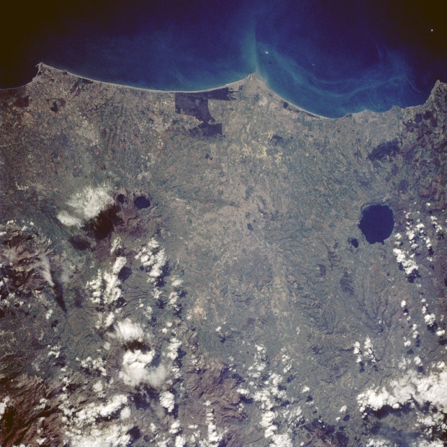 |
| STS060-090-028 Rome, Italy February 1994 Near the center of the this near-vertical photograph, the Eternal City of Rome is seeable. A great cultural, religious, and intellectual center, Rome is also one of the world's richest cities in history and art. Rome lies astride the Tiber River and its affluent, the Aniene River, about 15 miles (25 kilometers) from the point where the Tiber flows into the Tyrrhenian Sea (southwestern upper center of the photograph). The city is situated on a flat plain rimmed on the northwest by the Sabatini Hills, on the east by the Sabini and Prenestini Hills, and on the southeast by the Alban Hills. The Tiber River, 251 miles (404 kilometers) long and rising in the Etruscan Apennines of central Italy, is subject to flooding; thus, most of its banks, especially in Rome, are diked. Rome is a center for banking, insurance, printing and publishing, and fashion. Italy's movie industry is located at nearby Cinecitta. Tourism is a major industry. Other manufactures include construction, foodstuffs, soap, chemicals, textiles, leather, and metal goods. The administrative offices of the Roman Catholic Church and the home of the Pope are located in Vatican City within Rome. Bracciano Lake, the caldera of an extinct volcano, occupies 22 square miles (57 square kilometers) 17 miles (27 kilometers) northwest of Rome. Approximately 12 miles (19 kilometers) southeast of Rome is Albano Lake, another crater lake of an extinct volcano. The runways of the Leonardo da Vinci International Airport northwest of the mouth of the Tiber River and the famous World War II city of Anzio (Cape Anzio) southeast of the river's mouth are visible. |
| Images: | All Available Images Low-Resolution 151k |
|
| Mission: | STS060 |
|
| Roll - Frame: | 90 - 28 |
|
| Geographical Name: | ITALY |
|
| Features: | ROME, TIBER RIVER |
|
| Center Lat x Lon: | 42.0N x 12.5E |
|
| Film Exposure: | U | N=Normal exposure, U=Under exposed, O=Over exposed, F=out of Focus |
| Percentage of Cloud Cover-CLDP: | 15 |
|
| Camera:: | HB |
|
| Camera Tilt: | 37 | LO=Low Oblique, HO=High Oblique, NV=Near Vertical |
| Camera Focal Length: | 250 |
|
| Nadir to Photo Center Direction: | NW | The direction from the nadir to the center point, N=North, S=South, E=East, W=West |
| Stereo?: | N | Y=Yes there is an adjacent picture of the same area, N=No there isn't |
| Orbit Number: | 126 |
|
| Date: | 19940211 | YYYYMMDD |
| Time: | 112353 | GMT HHMMSS |
| Nadir Lat: | 40.6N |
Latitude of suborbital point of spacecraft |
| Nadir Lon: | 14.4E |
Longitude of suborbital point of spacecraft |
| Sun Azimuth: | 182 | Clockwise angle in degrees from north to the sun measured at the nadir point |
| Space Craft Altitude: | 191 | nautical miles |
| Sun Elevation: | 36 | Angle in degrees between the horizon and the sun, measured at the nadir point |
| Land Views: | COAST, HILL, MOUNTAIN, CAPE, VOLCANO, CRATER |
|
| Water Views: | RIVER, LAKE, SEDIMENT |
|
| Atmosphere Views: | |
|
| Man Made Views: | URBAN AREA, AIRPORT |
|
| City Views: | |
|
Photo is not associated with any sequences | ||
| NASA Home Page |
JSC Home Page |
JSC Digital Image Collection |
Earth Science & Remote Sensing |
|
This service is provided by the International Space Station program and the JSC Earth Science & Remote Sensing Unit, ARES Division, Exploration Integration Science Directorate.

|