
Geographic Region: ITALY
Feature: ELBA ISLAND
|
Geographic Region: ITALY Feature: ELBA ISLAND |
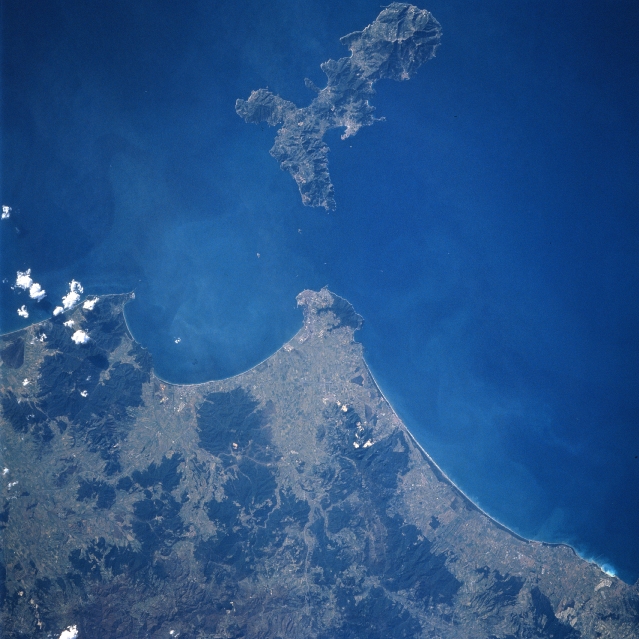 |
| STS060-090-017 Elba Island, Italy February, 1994 Elba Island (top center) is located 6 miles (10 km) southwest of the central west coast of Italy. The island is Italy's third largest island, behind Sicily and Sardinia. Elba has rugged topography with many hills and low mountains. Mount Capanne, elevation 3343 feet - 1018 meters, is the highest point on the island and is located towards the western end. In recent years tourism has become the island's chief source of revenue. The Italian city of Piombino is on the southwest tip of the peninsula that juts into the Piombino Channel. The embayment south of the peninsula is the Gulf of Follinica. The darker landscapes on the Italian mainland are wooded hills and low mountains. |
| Images: | All Available Images Low-Resolution 315k |
|
| Mission: | STS060 |
|
| Roll - Frame: | 90 - 17 |
|
| Geographical Name: | ITALY |
|
| Features: | ELBA ISLAND |
|
| Center Lat x Lon: | 42.5N x 10.5E |
|
| Film Exposure: | N | N=Normal exposure, U=Under exposed, O=Over exposed, F=out of Focus |
| Percentage of Cloud Cover-CLDP: | 5 |
|
| Camera:: | HB |
|
| Camera Tilt: | 15 | LO=Low Oblique, HO=High Oblique, NV=Near Vertical |
| Camera Focal Length: | 250 |
|
| Nadir to Photo Center Direction: | SW | The direction from the nadir to the center point, N=North, S=South, E=East, W=West |
| Stereo?: | Y | Y=Yes there is an adjacent picture of the same area, N=No there isn't |
| Orbit Number: | 126 |
|
| Date: | 19940211 | YYYYMMDD |
| Time: | 112300 | GMT HHMMSS |
| Nadir Lat: | 43.0N |
Latitude of suborbital point of spacecraft |
| Nadir Lon: | 11.2E |
Longitude of suborbital point of spacecraft |
| Sun Azimuth: | 178 | Clockwise angle in degrees from north to the sun measured at the nadir point |
| Space Craft Altitude: | 191 | nautical miles |
| Sun Elevation: | 33 | Angle in degrees between the horizon and the sun, measured at the nadir point |
| Land Views: | ISLAND |
|
| Water Views: | GULF |
|
| Atmosphere Views: | |
|
| Man Made Views: | |
|
| City Views: | |
|
Photo is not associated with any sequences | ||
| NASA Home Page |
JSC Home Page |
JSC Digital Image Collection |
Earth Science & Remote Sensing |
|
This service is provided by the International Space Station program and the JSC Earth Science & Remote Sensing Unit, ARES Division, Exploration Integration Science Directorate.

|