
Geographic Region: ITALY
Feature: COAST NEAR PISA
|
Geographic Region: ITALY Feature: COAST NEAR PISA |
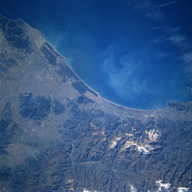 |
| STS060-090-015 Pisa Area, Italy February, 1994 The central west coast of Italy, roughly between La Spezia and Livorno, is captured in this southwest-looking view. This stretch of Italian coastline that borders the Ligurian Sea is sometimes referred too as the Tuscan Riviera because of its numerous beach resorts that rim the coastline. The Alpi Apuane range of picturesque mountains (some snow on the higher elevations in this image) serves as a scenic backdrop for the narrow coastal corridor. Paralleling this range of mountains to the east (bottom edge of image), a small section of the snow-capped Apennine Mountains is also visible. The Arno River Valley provides a strikingly different looking landscape south of the mountains. The extensive plains of the Arno River, is densely populated and intensely productive in terms of generating assorted agricultural products. The world famous city of Pisa is located near the coast on the Arno River. A runway (short, linear, light colored feature) of Pisa International Airport can be identified south of the city. The darker terrain seen along the immediate coast is vegetated wetlands. A small lake (roughly oval-shaped, dark feature) can be discerned near the center of the image. Light-colored plumes are visible in the near shore coastal waters. |
| Images: | All Available Images Low-Resolution 337k |
|
| Mission: | STS060 |
|
| Roll - Frame: | 90 - 15 |
|
| Geographical Name: | ITALY |
|
| Features: | COAST NEAR PISA |
|
| Center Lat x Lon: | 43.5N x 10.5E |
|
| Film Exposure: | N | N=Normal exposure, U=Under exposed, O=Over exposed, F=out of Focus |
| Percentage of Cloud Cover-CLDP: | 0 |
|
| Camera:: | HB |
|
| Camera Tilt: | 4 | LO=Low Oblique, HO=High Oblique, NV=Near Vertical |
| Camera Focal Length: | 250 |
|
| Nadir to Photo Center Direction: | NW | The direction from the nadir to the center point, N=North, S=South, E=East, W=West |
| Stereo?: | N | Y=Yes there is an adjacent picture of the same area, N=No there isn't |
| Orbit Number: | 126 |
|
| Date: | 19940211 | YYYYMMDD |
| Time: | 112251 | GMT HHMMSS |
| Nadir Lat: | 43.4N |
Latitude of suborbital point of spacecraft |
| Nadir Lon: | 10.7E |
Longitude of suborbital point of spacecraft |
| Sun Azimuth: | 177 | Clockwise angle in degrees from north to the sun measured at the nadir point |
| Space Craft Altitude: | 191 | nautical miles |
| Sun Elevation: | 33 | Angle in degrees between the horizon and the sun, measured at the nadir point |
| Land Views: | MOUNTAIN, COAST |
|
| Water Views: | SEA, SEDIMENT |
|
| Atmosphere Views: | |
|
| Man Made Views: | |
|
| City Views: | |
|
Photo is not associated with any sequences | ||
| NASA Home Page |
JSC Home Page |
JSC Digital Image Collection |
Earth Science & Remote Sensing |
|
This service is provided by the International Space Station program and the JSC Earth Science & Remote Sensing Unit, ARES Division, Exploration Integration Science Directorate.

|