
Geographic Region: USA-TEXAS
Feature: BROWNSVILLE, MATAMOROS
|
Geographic Region: USA-TEXAS Feature: BROWNSVILLE, MATAMOROS |
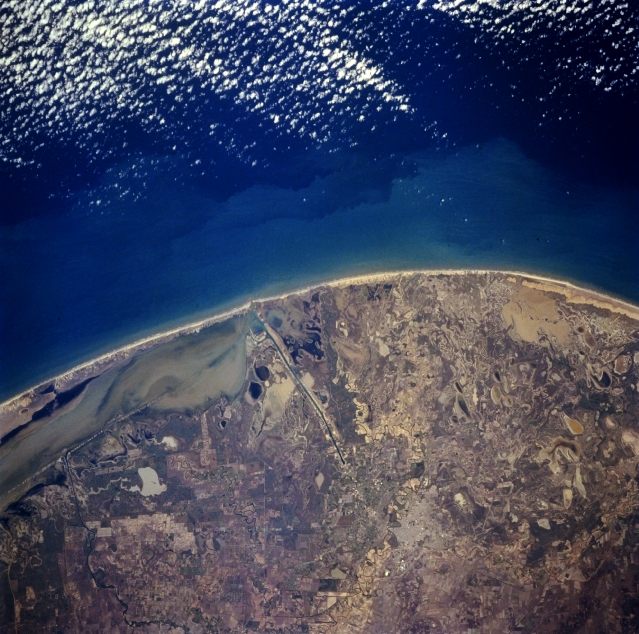 |
| STS060-083-050 Rio Grande Delta, Texas, U.S.A. February 1994 The Rio Grande almost disappears into the broad expanse of its delta as the river heads eastward toward the Gulf of Mexico. The water channel of the Rio Grande is discernible by evaluating color differences on either side of it. Visible are the linear, dredged Brownsville Ship Channel and the southern end of Padre Island, part of a chain of sandy barrier islands found along this coastline that creates large, muddy Laguna Madre. Large quantities of sand are transported by air and water, generally northwest across the delta and coastal areas. Much of the fertile land north of Brownsville is used for agriculture; whereas, the coastline consists of tidal flats, sandy soils, sand dunes, and small lagoons. |
| Images: | All Available Images Low-Resolution 370k |
|
| Mission: | STS060 |
|
| Roll - Frame: | 83 - 50 |
|
| Geographical Name: | USA-TEXAS |
|
| Features: | BROWNSVILLE, MATAMOROS |
|
| Center Lat x Lon: | 26.0N x 97W |
|
| Film Exposure: | N | N=Normal exposure, U=Under exposed, O=Over exposed, F=out of Focus |
| Percentage of Cloud Cover-CLDP: | 10 |
|
| Camera:: | HB |
|
| Camera Tilt: | 30 | LO=Low Oblique, HO=High Oblique, NV=Near Vertical |
| Camera Focal Length: | 250 |
|
| Nadir to Photo Center Direction: | N | The direction from the nadir to the center point, N=North, S=South, E=East, W=West |
| Stereo?: | N | Y=Yes there is an adjacent picture of the same area, N=No there isn't |
| Orbit Number: | 116 |
|
| Date: | 19940210 | YYYYMMDD |
| Time: | 201321 | GMT HHMMSS |
| Nadir Lat: | 24.3N |
Latitude of suborbital point of spacecraft |
| Nadir Lon: | 97.8W |
Longitude of suborbital point of spacecraft |
| Sun Azimuth: | 212 | Clockwise angle in degrees from north to the sun measured at the nadir point |
| Space Craft Altitude: | 192 | nautical miles |
| Sun Elevation: | 46 | Angle in degrees between the horizon and the sun, measured at the nadir point |
| Land Views: | COAST, PLAIN |
|
| Water Views: | DELTA, RIVER, CHANNEL, LAGOON |
|
| Atmosphere Views: | |
|
| Man Made Views: | |
|
| City Views: | |
|
Photo is not associated with any sequences | ||
| NASA Home Page |
JSC Home Page |
JSC Digital Image Collection |
Earth Science & Remote Sensing |
|
This service is provided by the International Space Station program and the JSC Earth Science & Remote Sensing Unit, ARES Division, Exploration Integration Science Directorate.

|