
Geographic Region: USA-ARIZONA
Feature: GRAND CANYON,KAIBAB PLAT
|
Geographic Region: USA-ARIZONA Feature: GRAND CANYON,KAIBAB PLAT |
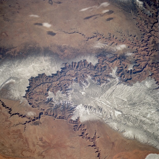 |
| STS060-083-005 Grand Canyon, Arizona, U.S.A. February 1994 The Grand Canyon, one of the deepest canyons in the world with a depth of 1 mile (1.6 kilometers), can be seen in this spectacular, west-looking, low-oblique photograph. The Colorado River cut through rocks billions of years old to create this canyon. The Grand Canyon is 277 miles (466 kilometers) long and averages nearly 10 miles (16 kilometers) in width. The snow-covered, forested Kaibab Plateau (north of the canyon) and the Coconino Plateau (south of the canyon) are visible. The western portions of the Painted Desert can be seen east of the canyon where the Little Colorado River joins the Colorado River. |
| Images: | All Available Images Low-Resolution 154k |
|
| Mission: | STS060 |
|
| Roll - Frame: | 83 - 5 |
|
| Geographical Name: | USA-ARIZONA |
|
| Features: | GRAND CANYON,KAIBAB PLAT |
|
| Center Lat x Lon: | 36.0N x 112W |
|
| Film Exposure: | N | N=Normal exposure, U=Under exposed, O=Over exposed, F=out of Focus |
| Percentage of Cloud Cover-CLDP: | 5 |
|
| Camera:: | HB |
|
| Camera Tilt: | 43 | LO=Low Oblique, HO=High Oblique, NV=Near Vertical |
| Camera Focal Length: | 250 |
|
| Nadir to Photo Center Direction: | SW | The direction from the nadir to the center point, N=North, S=South, E=East, W=West |
| Stereo?: | Y | Y=Yes there is an adjacent picture of the same area, N=No there isn't |
| Orbit Number: | 116 |
|
| Date: | 19940210 | YYYYMMDD |
| Time: | 200900 | GMT HHMMSS |
| Nadir Lat: | 37.5N |
Latitude of suborbital point of spacecraft |
| Nadir Lon: | 109.5W |
Longitude of suborbital point of spacecraft |
| Sun Azimuth: | 191 | Clockwise angle in degrees from north to the sun measured at the nadir point |
| Space Craft Altitude: | 191 | nautical miles |
| Sun Elevation: | 38 | Angle in degrees between the horizon and the sun, measured at the nadir point |
| Land Views: | PLATEAU, DESERT, MOUNTAIN, VALLEY |
|
| Water Views: | RIVER, LAKE |
|
| Atmosphere Views: | |
|
| Man Made Views: | |
|
| City Views: | |
|
Photo is not associated with any sequences | ||
| NASA Home Page |
JSC Home Page |
JSC Digital Image Collection |
Earth Science & Remote Sensing |
|
This service is provided by the International Space Station program and the JSC Earth Science & Remote Sensing Unit, ARES Division, Exploration Integration Science Directorate.

|