
Geographic Region: USA-NEW MEXICO
Feature: S. ANDRES MTS,WHITE SANDS
|
Geographic Region: USA-NEW MEXICO Feature: S. ANDRES MTS,WHITE SANDS |
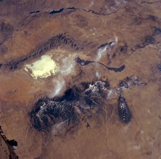 |
| STS060-072-044 Tularosa Valley, New Mexico, U.S.A. February 1994 Despite a few wispy clouds over the Tularosa Valley (center of photograph) in south-central New Mexico, numerous features are recognizable in this west-looking photograph. Visible are (from top to bottom) a segment of the Rio Grande and Elephant Butte Reservoir; the linear San Andres Mountains; White Sands National Monument; a dark, ribbonlike lava flow; and the Sacramento, Sierra Blanca, and Capitan Mountains with drainage patterns radiating eastward. Part of the Space Shuttle is apparent in the lower left corner. |
| Images: | All Available Images Low-Resolution 335k |
|
| Mission: | STS060 |
|
| Roll - Frame: | 72 - 44 |
|
| Geographical Name: | USA-NEW MEXICO |
|
| Features: | S. ANDRES MTS,WHITE SANDS |
|
| Center Lat x Lon: | 33.5N x 106.5W |
|
| Film Exposure: | N | N=Normal exposure, U=Under exposed, O=Over exposed, F=out of Focus |
| Percentage of Cloud Cover-CLDP: | 5 |
|
| Camera:: | HB |
|
| Camera Tilt: | 34 | LO=Low Oblique, HO=High Oblique, NV=Near Vertical |
| Camera Focal Length: | 100 |
|
| Nadir to Photo Center Direction: | W | The direction from the nadir to the center point, N=North, S=South, E=East, W=West |
| Stereo?: | N | Y=Yes there is an adjacent picture of the same area, N=No there isn't |
| Orbit Number: | 54 |
|
| Date: | 19940206 | YYYYMMDD |
| Time: | 213353 | GMT HHMMSS |
| Nadir Lat: | 33.2N |
Latitude of suborbital point of spacecraft |
| Nadir Lon: | 104.4W |
Longitude of suborbital point of spacecraft |
| Sun Azimuth: | 221 | Clockwise angle in degrees from north to the sun measured at the nadir point |
| Space Craft Altitude: | 190 | nautical miles |
| Sun Elevation: | 31 | Angle in degrees between the horizon and the sun, measured at the nadir point |
| Land Views: | VALLEY, MOUNTAIN, DUNE |
|
| Water Views: | RIVER |
|
| Atmosphere Views: | |
|
| Man Made Views: | |
|
| City Views: | |
|
Photo is not associated with any sequences | ||
| NASA Home Page |
JSC Home Page |
JSC Digital Image Collection |
Earth Science & Remote Sensing |
|
This service is provided by the International Space Station program and the JSC Earth Science & Remote Sensing Unit, ARES Division, Exploration Integration Science Directorate.

|