
Geographic Region: LEBANON
Feature: BEIRUT,LEBANON MTS,COAST
|
Geographic Region: LEBANON Feature: BEIRUT,LEBANON MTS,COAST |
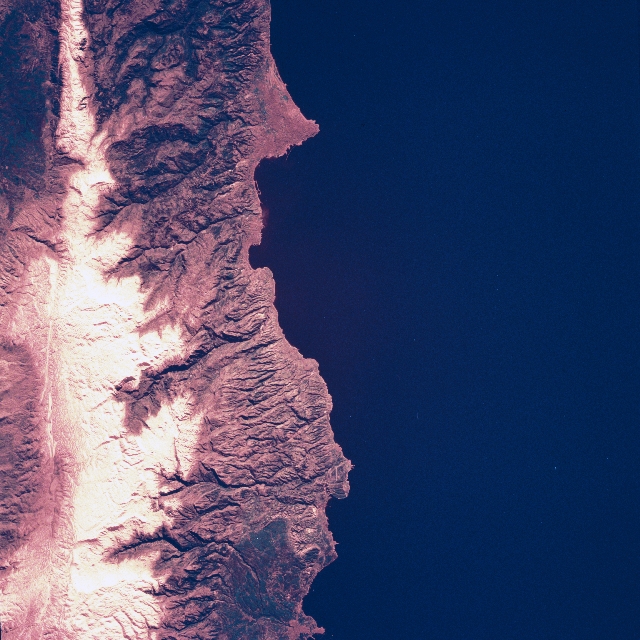 |
| STS060-107-023 Lebanon Mountains, Beirut, Lebanon February 1994 The rugged Lebanon Mountains can be seen rising from the narrow coastal plain in this mostly east-looking view. Snow covers the high peaks, which rise to over 11020 feet (3360 meters) at the left (north) of the image to over 8000 feet (2685 meters) at the right (south) on the image. Numerous river valleys descend down the western slopes of the mountain range to the Mediterranean Sea. At the left center of the image, the port city of Tripoli is located on the Mediterranean Sea coast. Tripoli has an oil refinery and is the terminus of an oil pipeline from Iraq. Citrus fruits and cotton are grown on the narrow coastal plain east of the city. Near the right center of the image is the capital and largest city in Lebanon, Beirut. Known as the "Paris of the East" before the civil war began in 1975 Beirut is now known as "the city that wouldn't die." The wounds from the Civil War, which ended in 1992, are still visible, but the city is slowly rebuilding. Before the war, Beruit was an important port and a commercial and financial center with many food-processing industries. The runways of the Beirut International Airport are discernible to the south of the city. |
| Images: | All Available Images Low-Resolution 356k |
|
| Mission: | STS060 |
|
| Roll - Frame: | 107 - 23 |
|
| Geographical Name: | LEBANON |
|
| Features: | BEIRUT,LEBANON MTS,COAST |
|
| Center Lat x Lon: | 34.0N x 35.5E |
|
| Film Exposure: | N | N=Normal exposure, U=Under exposed, O=Over exposed, F=out of Focus |
| Percentage of Cloud Cover-CLDP: | 0 |
|
| Camera:: | HB |
|
| Camera Tilt: | 16 | LO=Low Oblique, HO=High Oblique, NV=Near Vertical |
| Camera Focal Length: | 250 |
|
| Nadir to Photo Center Direction: | N | The direction from the nadir to the center point, N=North, S=South, E=East, W=West |
| Stereo?: | N | Y=Yes there is an adjacent picture of the same area, N=No there isn't |
| Orbit Number: | 48 |
|
| Date: | 19940206 | YYYYMMDD |
| Time: | 122430 | GMT HHMMSS |
| Nadir Lat: | 33.2N |
Latitude of suborbital point of spacecraft |
| Nadir Lon: | 35.1E |
Longitude of suborbital point of spacecraft |
| Sun Azimuth: | 223 | Clockwise angle in degrees from north to the sun measured at the nadir point |
| Space Craft Altitude: | 190 | nautical miles |
| Sun Elevation: | 30 | Angle in degrees between the horizon and the sun, measured at the nadir point |
| Land Views: | MOUNTAIN, VALLEY, COAST |
|
| Water Views: | SEA |
|
| Atmosphere Views: | |
|
| Man Made Views: | URBAN AREA, AIRPORT |
|
| City Views: | BEIRUT |
|
Photo is not associated with any sequences | ||
| NASA Home Page |
JSC Home Page |
JSC Digital Image Collection |
Earth Science & Remote Sensing |
|
This service is provided by the International Space Station program and the JSC Earth Science & Remote Sensing Unit, ARES Division, Exploration Integration Science Directorate.

|