
Geographic Region: USA-OREGON
Feature: CRESENT LAKE,CRATER LAKE
|
Geographic Region: USA-OREGON Feature: CRESENT LAKE,CRATER LAKE |
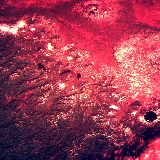 |
| STS060-105-026 Cascade Range and Crater Lake, Oregon, U.S.A. February 1994 The unusual reds of the Russian film used for this photograph distort the colors, making it appear different from most of the other photographs in this database, which were made using almost exclusively natural color films. This film enhances some of the snow-covered high elevations, the snow-covered frozen lakes, certain forested landscapes where clearcutting has occurred (showing these areas as white or red rectangles), and open bodies of water (delineating lakes and reservoirs). The main axis of volcanoes that extends through this part of Oregon can be traced from Crater Lake in the south to the snowcapped Three Sisters Volcanoes in the north, a distance of approximately 85 miles (140 kilometers). Part of the extensive, forested Cascade Range appears as the darker landscape west of this volcano zone. The broad valley east of Crater Lake is a portion of Klamath Marsh (formerly Lower Klamath Lake). |
| Images: | All Available Images Low-Resolution 445k |
|
| Mission: | STS060 |
|
| Roll - Frame: | 105 - 26 |
|
| Geographical Name: | USA-OREGON |
|
| Features: | CRESENT LAKE,CRATER LAKE |
|
| Center Lat x Lon: | 43.5N x 122W |
|
| Film Exposure: | N | N=Normal exposure, U=Under exposed, O=Over exposed, F=out of Focus |
| Percentage of Cloud Cover-CLDP: | 0 |
|
| Camera:: | HB |
|
| Camera Tilt: | 49 | LO=Low Oblique, HO=High Oblique, NV=Near Vertical |
| Camera Focal Length: | 250 |
|
| Nadir to Photo Center Direction: | NE | The direction from the nadir to the center point, N=North, S=South, E=East, W=West |
| Stereo?: | Y | Y=Yes there is an adjacent picture of the same area, N=No there isn't |
| Orbit Number: | 39 |
|
| Date: | 19940205 | YYYYMMDD |
| Time: | 223733 | GMT HHMMSS |
| Nadir Lat: | 41.5N |
Latitude of suborbital point of spacecraft |
| Nadir Lon: | 125W |
Longitude of suborbital point of spacecraft |
| Sun Azimuth: | 213 | Clockwise angle in degrees from north to the sun measured at the nadir point |
| Space Craft Altitude: | 190 | nautical miles |
| Sun Elevation: | 26 | Angle in degrees between the horizon and the sun, measured at the nadir point |
| Land Views: | RANGE, VOLCANO, FOREST |
|
| Water Views: | |
|
| Atmosphere Views: | |
|
| Man Made Views: | |
|
| City Views: | |
|
Photo is not associated with any sequences | ||
| NASA Home Page |
JSC Home Page |
JSC Digital Image Collection |
Earth Science & Remote Sensing |
|
This service is provided by the International Space Station program and the JSC Earth Science & Remote Sensing Unit, ARES Division, Exploration Integration Science Directorate.

|