
Geographic Region: MEXICO
Feature: OHVIRA BAY, AGRICULTURE
|
Geographic Region: MEXICO Feature: OHVIRA BAY, AGRICULTURE |
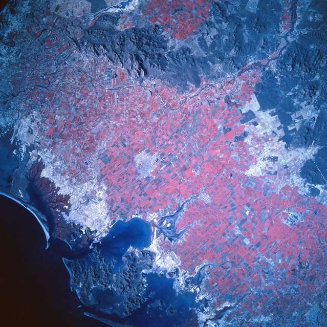 |
| STS060-101-053 La Mochis Area, Mexico February 1994 The color infrared image helps to identify the extensive land area that is being used for commercial agriculture along this coastal section of northwest Mexico. Notice the sizeable, angular field patterns (red colors map the extent of healthy green plants) that are widespread across the dry coastal plain of Sinaloa State. La Mochis, visible near the center of the image, has been a boomtown since the 1950's when the rapid growth of irrigated agriculture started to take in this semiarid region of northern Mexico. Wheat, cotton, soybean, oilseeds, and winter vegetables, especially tomatoes are among the main crops grown. Low mountains (darker, more textured-looking landscape) can be discriminated along the coast (bottom center) and north of the Fuerte River (top center). The dark-looking, uniform feature south of La Mochis is Ohvira Bay, one of many bays that indent this section of coastline in northwest Mexico. The lighter colored landscape inland from the coast shows poorly drained topography that contains virtually no permanent vegetative cover. |
| Images: | All Available Images Low-Resolution 421k |
|
| Mission: | STS060 |
|
| Roll - Frame: | 101 - 53 |
|
| Geographical Name: | MEXICO |
|
| Features: | OHVIRA BAY, AGRICULTURE |
|
| Center Lat x Lon: | 25.5N x 108.5W |
|
| Film Exposure: | N | N=Normal exposure, U=Under exposed, O=Over exposed, F=out of Focus |
| Percentage of Cloud Cover-CLDP: | 0 |
|
| Camera:: | HB |
|
| Camera Tilt: | 22 | LO=Low Oblique, HO=High Oblique, NV=Near Vertical |
| Camera Focal Length: | 250 |
|
| Nadir to Photo Center Direction: | E | The direction from the nadir to the center point, N=North, S=South, E=East, W=West |
| Stereo?: | Y | Y=Yes there is an adjacent picture of the same area, N=No there isn't |
| Orbit Number: | 39 |
|
| Date: | 19940205 | YYYYMMDD |
| Time: | 224250 | GMT HHMMSS |
| Nadir Lat: | 26.0N |
Latitude of suborbital point of spacecraft |
| Nadir Lon: | 109.7W |
Longitude of suborbital point of spacecraft |
| Sun Azimuth: | 233 | Clockwise angle in degrees from north to the sun measured at the nadir point |
| Space Craft Altitude: | 190 | nautical miles |
| Sun Elevation: | 28 | Angle in degrees between the horizon and the sun, measured at the nadir point |
| Land Views: | |
|
| Water Views: | |
|
| Atmosphere Views: | |
|
| Man Made Views: | |
|
| City Views: | |
|
Photo is not associated with any sequences | ||
| NASA Home Page |
JSC Home Page |
JSC Digital Image Collection |
Earth Science & Remote Sensing |
|
This service is provided by the International Space Station program and the JSC Earth Science & Remote Sensing Unit, ARES Division, Exploration Integration Science Directorate.

|