
Geographic Region: AUSTRALIA-Q
Feature: GREAT BARRIER REEF
|
Geographic Region: AUSTRALIA-Q Feature: GREAT BARRIER REEF |
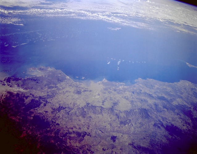 |
| STS059-L22-035 Great Barrier Reef, Queensland, Australia April 1994 The southern end of the largest and longest coral formation in the world, Australia's Great Barrier Reef, is shown in this synoptic, low-oblique, northeast-looking photograph. This particular section of the reef off the northeast Queensland coast lies just north of the Capricorn Channel. The total reef structure is made up of a complex assemblage of more than 2500 individual reefs and 300 coral islands. This northwest-southeast-trending reef extends for roughly 1200 miles (1900 kilometers) along the northeast coast of Australia. A series of low, forested, coastal mountains with elevations between 1500 and 3000 feet (450 and 900 meters) above sea level is clearly visible throughout the coastal region. A sizable sediment plume extends into Broad Sound, which is fed by several short-flowing rivers. This type of sediment plume can produce a negative impact on the coral reef because the tiny creatures that comprise the reef cannot survive in very dirty water. The Australian Government has set aside the Great Barrier Reef as a national marine park, and this region has evolved into a major tourist attraction for both domestic and international visitors. |
| Images: | All Available Images Low-Resolution 92k |
|
| Mission: | STS059 |
|
| Roll - Frame: | L22 - 35 |
|
| Geographical Name: | AUSTRALIA-Q |
|
| Features: | GREAT BARRIER REEF |
|
| Center Lat x Lon: | 22S x 151.0E |
|
| Film Exposure: | N | N=Normal exposure, U=Under exposed, O=Over exposed, F=out of Focus |
| Percentage of Cloud Cover-CLDP: | 15 |
|
| Camera:: | LH |
|
| Camera Tilt: | LO | LO=Low Oblique, HO=High Oblique, NV=Near Vertical |
| Camera Focal Length: | 90 |
|
| Nadir to Photo Center Direction: | E | The direction from the nadir to the center point, N=North, S=South, E=East, W=West |
| Stereo?: | N | Y=Yes there is an adjacent picture of the same area, N=No there isn't |
| Orbit Number: | 46 |
|
| Date: | 19940412 | YYYYMMDD |
| Time: | 063058 | GMT HHMMSS |
| Nadir Lat: | 22.9S |
Latitude of suborbital point of spacecraft |
| Nadir Lon: | 148.2E |
Longitude of suborbital point of spacecraft |
| Sun Azimuth: | 288 | Clockwise angle in degrees from north to the sun measured at the nadir point |
| Space Craft Altitude: | 120 | nautical miles |
| Sun Elevation: | 18 | Angle in degrees between the horizon and the sun, measured at the nadir point |
| Land Views: | COAST |
|
| Water Views: | OCEAN, SEA, REEF |
|
| Atmosphere Views: | |
|
| Man Made Views: | |
|
| City Views: | |
|
Photo is not associated with any sequences | ||
| NASA Home Page |
JSC Home Page |
JSC Digital Image Collection |
Earth Science & Remote Sensing |
|
This service is provided by the International Space Station program and the JSC Earth Science & Remote Sensing Unit, ARES Division, Exploration Integration Science Directorate.

|