Geographic Region: DENMARK
Feature: SKAGERRAK, KATTEGAT
|
Geographic Region: DENMARK Feature: SKAGERRAK, KATTEGAT |
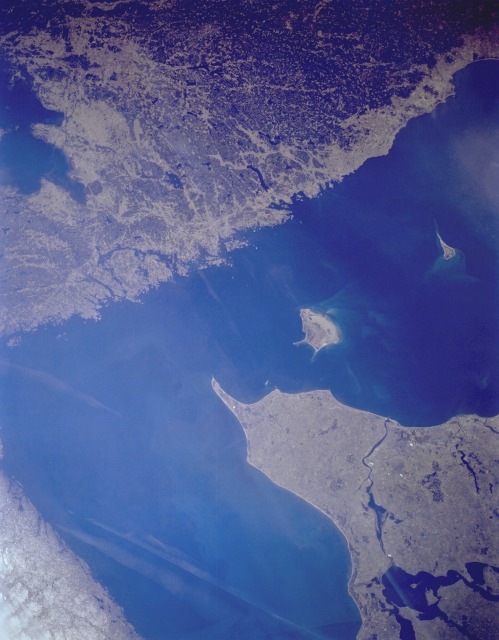 |
| STS-059-L22-115 Skagerrak and Kattegat, Scandinavia April 1994 Two major bodies of water, the Skagerrak and the Kattegat, separate the Scandinavian Peninsula and the Jutland (Jylland) Peninsula of Denmark. The Skagerrak, a broad extension of the North Sea, lies north-northwest of the Jutland Peninsula, and the Kattegat lies east of the peninsula, separating Denmark from Sweden. Two islands, both belonging to Denmark, appear in the Kattegat--larger Laesø and smaller Anholt, about 45 miles (70 kilometers) east of Jutland. Because of the small scale of this photograph, no specific urban infrastructure can be observed; however, Skagen, a busy fishing port and resort, is located near the northernmost tip of Jutland Peninsula. The peninsula's west coast is windswept with sandy, poor quality soils, but the east coast has fertile soils and is densely populated. Livestock raising and dairying are the main occupations on Jutland. On the Swedish coast of the Kattegat, numerous urban areas are located but cannot be specifically identified--among them, Göteborg, Sweden's leading seaport and an important commercial center in this area of Sweden. |
| Images: | All Available Images Low-Resolution 88k |
|
| Mission: | STS059 |
|
| Roll - Frame: | L22 - 115 |
|
| Geographical Name: | DENMARK |
|
| Features: | SKAGERRAK, KATTEGAT |
|
| Center Lat x Lon: | 58.0N x 10.5E |
|
| Film Exposure: | N | N=Normal exposure, U=Under exposed, O=Over exposed, F=out of Focus |
| Percentage of Cloud Cover-CLDP: | 0 |
|
| Camera:: | LH |
|
| Camera Tilt: | 27 | LO=Low Oblique, HO=High Oblique, NV=Near Vertical |
| Camera Focal Length: | 90 |
|
| Nadir to Photo Center Direction: | N | The direction from the nadir to the center point, N=North, S=South, E=East, W=West |
| Stereo?: | Y | Y=Yes there is an adjacent picture of the same area, N=No there isn't |
| Orbit Number: | 48 |
|
| Date: | 19940412 | YYYYMMDD |
| Time: | 090026 | GMT HHMMSS |
| Nadir Lat: | 57.0N |
Latitude of suborbital point of spacecraft |
| Nadir Lon: | 10.5E |
Longitude of suborbital point of spacecraft |
| Sun Azimuth: | 137 | Clockwise angle in degrees from north to the sun measured at the nadir point |
| Space Craft Altitude: | 117 | nautical miles |
| Sun Elevation: | 35 | Angle in degrees between the horizon and the sun, measured at the nadir point |
| Land Views: | COAST |
|
| Water Views: | BAY, CHANNEL, SEA, STRAIT |
|
| Atmosphere Views: | |
|
| Man Made Views: | |
|
| City Views: | |
|
Photo is not associated with any sequences | ||
| NASA Home Page |
JSC Home Page |
JSC Digital Image Collection |
Earth Science & Remote Sensing |
|
This service is provided by the International Space Station program and the JSC Earth Science & Remote Sensing Unit, ARES Division, Exploration Integration Science Directorate.

|