Geographic Region: MONGOLIA
Feature: PAN-VALLEY OF THE LAKES
|
Geographic Region: MONGOLIA Feature: PAN-VALLEY OF THE LAKES |
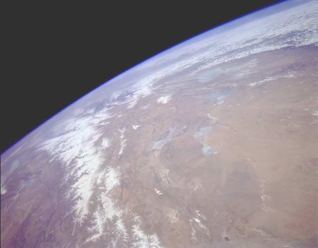 |
| STS059-L17-031 Valley of The Lakes, Western Mongolia April 1994 The snow-covered Altai Mountain system, trending northwest-southeast, straddles the border between western Mongolia and extreme northwest China. The Altai Mountains separate two very large, desert, sparsely inhabited regions--the Valley of the Lakes in western Mongolia and the Dzungarian Basin in northwestern China. The brownish intermontane basin of the Valley of the Lakes region shows an assortment of desert landforms--alluvial fans, inland river deltas, intermittently flowing streams, and dry lakebeds. The four larger lakes captured in this photograph are Uvs (the northernmost lake partially obscured by cirrus clouds); Hyargas (immediately south of Uvs); Hara and Doroo (south of Hyagas); and Har Us (west of Hara). Each of these lakes is fed by the runoff from glaciers and snowmelt from mountains. When this photograph was taken, most of these lakes were partially covered with ice. The intermittently flowing Dzavhan River, which runs generally east to west toward three of these lakes, is a very narrow watercourse that dramatically stands out against an otherwise barren landscape. Two sizable Chinese lakes are visible southwest of the Altai Mountains. |
| Images: | All Available Images Low-Resolution 57k |
|
| Mission: | STS059 |
|
| Roll - Frame: | L17 - 31 |
|
| Geographical Name: | MONGOLIA |
|
| Features: | PAN-VALLEY OF THE LAKES |
|
| Center Lat x Lon: | 49.0N x 91.5E |
|
| Film Exposure: | N | N=Normal exposure, U=Under exposed, O=Over exposed, F=out of Focus |
| Percentage of Cloud Cover-CLDP: | 20 |
|
| Camera:: | LH |
|
| Camera Tilt: | HO | LO=Low Oblique, HO=High Oblique, NV=Near Vertical |
| Camera Focal Length: | 90 |
|
| Nadir to Photo Center Direction: | NW | The direction from the nadir to the center point, N=North, S=South, E=East, W=West |
| Stereo?: | Y | Y=Yes there is an adjacent picture of the same area, N=No there isn't |
| Orbit Number: | 78 |
|
| Date: | 19940414 | YYYYMMDD |
| Time: | 053100 | GMT HHMMSS |
| Nadir Lat: | 45.5N |
Latitude of suborbital point of spacecraft |
| Nadir Lon: | 94.8E |
Longitude of suborbital point of spacecraft |
| Sun Azimuth: | 176 | Clockwise angle in degrees from north to the sun measured at the nadir point |
| Space Craft Altitude: | 116 | nautical miles |
| Sun Elevation: | 54 | Angle in degrees between the horizon and the sun, measured at the nadir point |
| Land Views: | MOUNTAIN, GLACIER, VALLEY, DESERT |
|
| Water Views: | LAKE |
|
| Atmosphere Views: | |
|
| Man Made Views: | |
|
| City Views: | |
|
Photo is not associated with any sequences | ||
| NASA Home Page |
JSC Home Page |
JSC Digital Image Collection |
Earth Science & Remote Sensing |
|
This service is provided by the International Space Station program and the JSC Earth Science & Remote Sensing Unit, ARES Division, Exploration Integration Science Directorate.

|