Geographic Region: JAPAN
Feature: KYUSHU, BAYS, MTS,RIVERS
|
Geographic Region: JAPAN Feature: KYUSHU, BAYS, MTS,RIVERS |
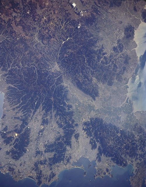 |
| STS059-L16-0BA Fukuoka, Kyushu, Japan April 1994 The northwest coast of Kyushu Island that faces the eastern channel of the Korea Strait contains numerous natural harbors, peninsulas, and fragmented-mountains (darker looking terrain with prominate drainage patterns). Urban development and agricultural activities are concentrated on the fertile coastal plains and the mountain valleys (lighter-colored areas). The modern port city of Fukuoka (1.2 million population - 1993 estimate) with its angular-shaped manmade peninsulas (series of docks, wharfs, and piers) is visible along the south side of the bay that is located at the bottom (near the center) of the image. The Chikugo River (linear, light-colored feature) can be traced across the intensively cultivated fertile plain (large light-colored area near the right middle) as the river drains generally westward. Sunglint (sun's reflection off of the river's surface) helps to accentuate the drainage pattern (largely dendretic) of the Chikugo River Basin, from its headwater areas in the mountains of north central Kyushu to its delta where the river flows into the Ariakeno Bay (right edge of the image). |
| Images: | All Available Images Low-Resolution 319k |
|
| Mission: | STS059 |
|
| Roll - Frame: | L16 - BA |
|
| Geographical Name: | JAPAN |
|
| Features: | KYUSHU, BAYS, MTS,RIVERS |
|
| Center Lat x Lon: | 33.5N x 131.0E |
|
| Film Exposure: | N | N=Normal exposure, U=Under exposed, O=Over exposed, F=out of Focus |
| Percentage of Cloud Cover-CLDP: | 0 |
|
| Camera:: | LH |
|
| Camera Tilt: | 24 | LO=Low Oblique, HO=High Oblique, NV=Near Vertical |
| Camera Focal Length: | 250 |
|
| Nadir to Photo Center Direction: | SW | The direction from the nadir to the center point, N=North, S=South, E=East, W=West |
| Stereo?: | Y | Y=Yes there is an adjacent picture of the same area, N=No there isn't |
| Orbit Number: | 77 |
|
| Date: | 19940414 | YYYYMMDD |
| Time: | 040614 | GMT HHMMSS |
| Nadir Lat: | 34.2N |
Latitude of suborbital point of spacecraft |
| Nadir Lon: | 131.5E |
Longitude of suborbital point of spacecraft |
| Sun Azimuth: | 209 | Clockwise angle in degrees from north to the sun measured at the nadir point |
| Space Craft Altitude: | 117 | nautical miles |
| Sun Elevation: | 63 | Angle in degrees between the horizon and the sun, measured at the nadir point |
| Land Views: | PLAIN, VALLEY |
|
| Water Views: | RIVER, BAY |
|
| Atmosphere Views: | |
|
| Man Made Views: | URBAN AREA |
|
| City Views: | |
|
Photo is not associated with any sequences | ||
| NASA Home Page |
JSC Home Page |
JSC Digital Image Collection |
Earth Science & Remote Sensing |
|
This service is provided by the International Space Station program and the JSC Earth Science & Remote Sensing Unit, ARES Division, Exploration Integration Science Directorate.

|