Geographic Region: ARGENTINA
Feature: ANDES MTS,VALLEY,PATOS R
|
Geographic Region: ARGENTINA Feature: ANDES MTS,VALLEY,PATOS R |
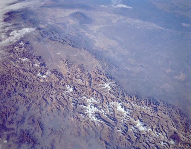 |
| STS059-L15-048 Mount Aconcagua, Southern Andes Mountains, Argentina and Chile April 1994 Mount Aconcagua, the highest mountain peak in the Americas (Western Hemisphere) at 22 830 feet (6958 meters) above sea level, is visible near the center of this low-oblique, northeast-looking photograph. Five major snow-covered peaks with summits exceeding 20 000 feet (6100 meters) rise along the north-south axis of the cohesive and massive structure of the Andes Mountains through this area of Argentina and Chile. Mount Aconcagua is the second snow-covered peak from the north. The narrow east-west valley immediately south of Mount Aconcagua contains a section of the Pan American Highway that connects Mendoza, Argentina, with Santiago, Chile. Mount Aconcagua and the snowcapped volcanic peak north of Mount Aconcagua lie within Argentina; the three snowcapped volcanic peaks south of Mount Aconcagua lie directly on the Chile-Argentina border. Several river basins are discernible on the eastern side of the Andes Mountains in west-central Argentina. Where sufficient water exists, mainly from snowmelt from the Andes Mountains, irrigated agriculture occurs in the otherwise dry valleys and basins east of the high Andes Mountains. |
| Images: | All Available Images Low-Resolution 117k |
|
| Mission: | STS059 |
|
| Roll - Frame: | L15 - 48 |
|
| Geographical Name: | ARGENTINA |
|
| Features: | ANDES MTS,VALLEY,PATOS R |
|
| Center Lat x Lon: | 32.5S x 69W |
|
| Film Exposure: | N | N=Normal exposure, U=Under exposed, O=Over exposed, F=out of Focus |
| Percentage of Cloud Cover-CLDP: | 10 |
|
| Camera:: | LH |
|
| Camera Tilt: | 49 | LO=Low Oblique, HO=High Oblique, NV=Near Vertical |
| Camera Focal Length: | 90 |
|
| Nadir to Photo Center Direction: | NE | The direction from the nadir to the center point, N=North, S=South, E=East, W=West |
| Stereo?: | Y | Y=Yes there is an adjacent picture of the same area, N=No there isn't |
| Orbit Number: | 104 |
|
| Date: | 19940415 | YYYYMMDD |
| Time: | 202218 | GMT HHMMSS |
| Nadir Lat: | 33.6S |
Latitude of suborbital point of spacecraft |
| Nadir Lon: | 70.9W |
Longitude of suborbital point of spacecraft |
| Sun Azimuth: | 300 | Clockwise angle in degrees from north to the sun measured at the nadir point |
| Space Craft Altitude: | 116 | nautical miles |
| Sun Elevation: | 22 | Angle in degrees between the horizon and the sun, measured at the nadir point |
| Land Views: | MOUNTAIN, GLACIER, VALLEY |
|
| Water Views: | |
|
| Atmosphere Views: | |
|
| Man Made Views: | |
|
| City Views: | |
|
Photo is not associated with any sequences | ||
| NASA Home Page |
JSC Home Page |
JSC Digital Image Collection |
Earth Science & Remote Sensing |
|
This service is provided by the International Space Station program and the JSC Earth Science & Remote Sensing Unit, ARES Division, Exploration Integration Science Directorate.

|