
Geographic Region: USA-CALIFORNIA
Feature: SACRAMENTO V,CARSON SINK
|
Geographic Region: USA-CALIFORNIA Feature: SACRAMENTO V,CARSON SINK |
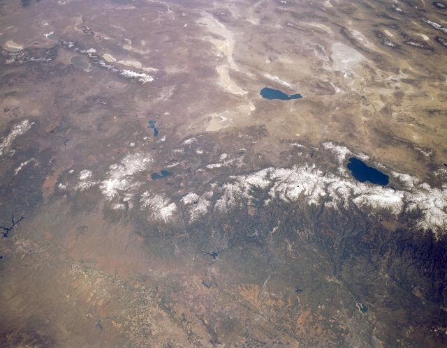 |
| STS059-L15-032 Sierra Nevada Mountains, California and Nevada, U.S.A. April 1994 The snow-capped northern Sierra Nevadas are featured in this low-oblique, northeast-looking, synoptic photograph. The Sierra Nevadas, the largest tilted fault block structure in the United States, provide snowmelt to the Sacramento Valley for irrigation. Visible are dark blue Lake Tahoe, a deep basin within the Sierra Nevadas, near the center right and light blue Pyramid Lake, named for the large pyramidal rocks surrounding it, to the north and east of Lake Tahoe. Viewing from Pyramid Lake are the north-south-trending Warner Mountains to the north-northwest; the dry, alkaline lakes of Smoke Creek Desert and Black Rock Desert to the north; and white, marshy Carson Sink to the east. |
| Images: | All Available Images Low-Resolution 271k |
|
| Mission: | STS059 |
|
| Roll - Frame: | L15 - 32 |
|
| Geographical Name: | USA-CALIFORNIA |
|
| Features: | SACRAMENTO V,CARSON SINK |
|
| Center Lat x Lon: | 40.0N x 121W |
|
| Film Exposure: | N | N=Normal exposure, U=Under exposed, O=Over exposed, F=out of Focus |
| Percentage of Cloud Cover-CLDP: | 0 |
|
| Camera:: | LH |
|
| Camera Tilt: | 39 | LO=Low Oblique, HO=High Oblique, NV=Near Vertical |
| Camera Focal Length: | 90 |
|
| Nadir to Photo Center Direction: | NE | The direction from the nadir to the center point, N=North, S=South, E=East, W=West |
| Stereo?: | Y | Y=Yes there is an adjacent picture of the same area, N=No there isn't |
| Orbit Number: | 104 |
|
| Date: | 19940415 | YYYYMMDD |
| Time: | 200015 | GMT HHMMSS |
| Nadir Lat: | 39.0N |
Latitude of suborbital point of spacecraft |
| Nadir Lon: | 122.2W |
Longitude of suborbital point of spacecraft |
| Sun Azimuth: | 176 | Clockwise angle in degrees from north to the sun measured at the nadir point |
| Space Craft Altitude: | 114 | nautical miles |
| Sun Elevation: | 61 | Angle in degrees between the horizon and the sun, measured at the nadir point |
| Land Views: | MOUNTAIN, BASIN, VALLEY |
|
| Water Views: | LAKE |
|
| Atmosphere Views: | |
|
| Man Made Views: | |
|
| City Views: | |
|
Photo is not associated with any sequences | ||
| NASA Home Page |
JSC Home Page |
JSC Digital Image Collection |
Earth Science & Remote Sensing |
|
This service is provided by the International Space Station program and the JSC Earth Science & Remote Sensing Unit, ARES Division, Exploration Integration Science Directorate.

|