
Geographic Region: USA-WYOMING
Feature: N PLATTE R., BIG HORN R.
|
Geographic Region: USA-WYOMING Feature: N PLATTE R., BIG HORN R. |
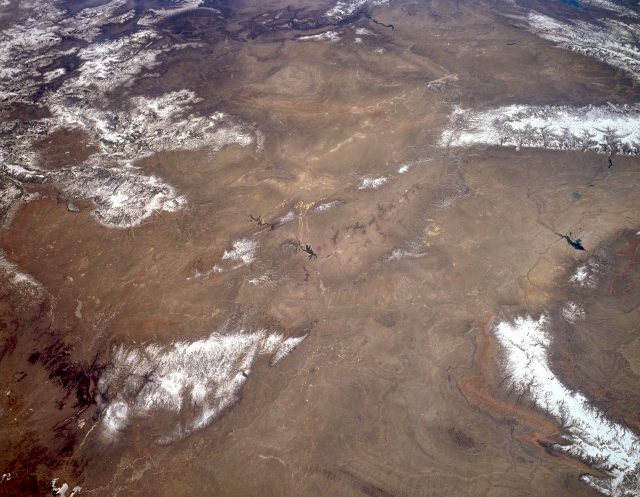 |
| STS059-L15-002 Great Divide Basin and Laramie and Bighorn Mountains, Wyoming, U.S.A. April 1994 This panoramic, southwest-looking, low-oblique photograph features most of southern and southwestern Wyoming. Visible clockwise from the top are the Uinta Mountains of northern Utah and elongated Flaming Gorge Reservoir; the southern portion of the Wyoming Range and the Wind River Range; and the Bighorn Basin, Boysen Reservoir, Bighorn Mountains, southern Powder River Basin, and Teapot Dome. Barely discernible (bottom left) are the Glendo Reservoir and the Laramie Mountains, a prong of the northern Colorado Front Range. Extending into Wyoming from northern Colorado, southwest of the Laramie Mountains, are the Medicine Bow Mountains, named by the Indians because of the abundance of ash wood from which to make bows and arrows for hunting, and the Sierra Madre, noted for deposits of copper. Barely discernible (center of photograph) are Pathfinder Reservoir and, to its south, smaller Seminoe Reservoir. |
| Images: | All Available Images Low-Resolution 274k |
|
| Mission: | STS059 |
|
| Roll - Frame: | L15 - 2 |
|
| Geographical Name: | USA-WYOMING |
|
| Features: | N PLATTE R., BIG HORN R. |
|
| Center Lat x Lon: | 42.5N x 107W |
|
| Film Exposure: | N | N=Normal exposure, U=Under exposed, O=Over exposed, F=out of Focus |
| Percentage of Cloud Cover-CLDP: | 5 |
|
| Camera:: | LH |
|
| Camera Tilt: | 42 | LO=Low Oblique, HO=High Oblique, NV=Near Vertical |
| Camera Focal Length: | 90 |
|
| Nadir to Photo Center Direction: | SW | The direction from the nadir to the center point, N=North, S=South, E=East, W=West |
| Stereo?: | Y | Y=Yes there is an adjacent picture of the same area, N=No there isn't |
| Orbit Number: | 103 |
|
| Date: | 19940415 | YYYYMMDD |
| Time: | 182954 | GMT HHMMSS |
| Nadir Lat: | 43.6N |
Latitude of suborbital point of spacecraft |
| Nadir Lon: | 105.7W |
Longitude of suborbital point of spacecraft |
| Sun Azimuth: | 165 | Clockwise angle in degrees from north to the sun measured at the nadir point |
| Space Craft Altitude: | 114 | nautical miles |
| Sun Elevation: | 56 | Angle in degrees between the horizon and the sun, measured at the nadir point |
| Land Views: | MOUNTAIN, BASIN, FAULT |
|
| Water Views: | |
|
| Atmosphere Views: | |
|
| Man Made Views: | |
|
| City Views: | |
|
Photo is not associated with any sequences | ||
| NASA Home Page |
JSC Home Page |
JSC Digital Image Collection |
Earth Science & Remote Sensing |
|
This service is provided by the International Space Station program and the JSC Earth Science & Remote Sensing Unit, ARES Division, Exploration Integration Science Directorate.

|