
Geographic Region: USA-WYOMING
Feature: ABSAROKA RA, BIG HORN R.
|
Geographic Region: USA-WYOMING Feature: ABSAROKA RA, BIG HORN R. |
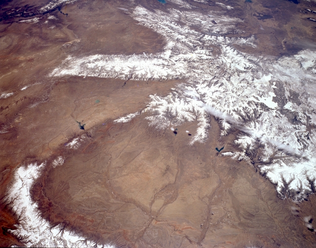 |
| STS059-L15-001 Bighorn Basin and Yellowstone, Wyoming, U.S.A. April 1994 The snow-covered highlands of Yellowstone and the irrigated agricultural lands of the central Bighorn Basin are featured in this south-southwest-looking, low-oblique, panoramic photograph. Large, oval Bighorn Basin spans 10 000 square miles (25 900 square kilometers), is 120 miles (193 kilometers) long and 60 miles (97 kilometers) wide, and is surrounded by forested mountains that rise more than 13 000 feet (3965 meters) to perpetually snowcapped summits except on the north where the basin merges with the Crazy Mountain Basin of south-central Montana (not visible). The center of the basin is low, flat, and dry. To the south lies the Great Divide Basin (left side). Viewing clockwise from ice-covered Yellowstone Lake (barely discernible) are the Absaroka Range; the Bighorn Mountains (lower left); the Bridger Mountains and Owl Creek Mountains, which extend westward from the Bighorn Mountains; the Wind River Range (north of the Great Divide Basin); the Wyoming and Salt River Ranges (top center); and the Snake River Plain of eastern Idaho (top right). The Bighorn, Shoshone, Greybull, and Clarks Fork Rivers carry runoff from the Absaroka Mountains across the Bighorn Basin and eventually empty into the Yellowstone River (not visible) in southern Montana. |
| Images: | All Available Images Low-Resolution 292k |
|
| Mission: | STS059 |
|
| Roll - Frame: | L15 - 1 |
|
| Geographical Name: | USA-WYOMING |
|
| Features: | ABSAROKA RA, BIG HORN R. |
|
| Center Lat x Lon: | 43.0N x 108.5W |
|
| Film Exposure: | N | N=Normal exposure, U=Under exposed, O=Over exposed, F=out of Focus |
| Percentage of Cloud Cover-CLDP: | 5 |
|
| Camera:: | LH |
|
| Camera Tilt: | 48 | LO=Low Oblique, HO=High Oblique, NV=Near Vertical |
| Camera Focal Length: | 90 |
|
| Nadir to Photo Center Direction: | S | The direction from the nadir to the center point, N=North, S=South, E=East, W=West |
| Stereo?: | Y | Y=Yes there is an adjacent picture of the same area, N=No there isn't |
| Orbit Number: | 103 |
|
| Date: | 19940415 | YYYYMMDD |
| Time: | 182923 | GMT HHMMSS |
| Nadir Lat: | 45.0N |
Latitude of suborbital point of spacecraft |
| Nadir Lon: | 107.8W |
Longitude of suborbital point of spacecraft |
| Sun Azimuth: | 162 | Clockwise angle in degrees from north to the sun measured at the nadir point |
| Space Craft Altitude: | 114 | nautical miles |
| Sun Elevation: | 54 | Angle in degrees between the horizon and the sun, measured at the nadir point |
| Land Views: | MOUNTAIN, BASIN, FAULT |
|
| Water Views: | |
|
| Atmosphere Views: | |
|
| Man Made Views: | |
|
| City Views: | |
|
Photo is not associated with any sequences | ||
| NASA Home Page |
JSC Home Page |
JSC Digital Image Collection |
Earth Science & Remote Sensing |
|
This service is provided by the International Space Station program and the JSC Earth Science & Remote Sensing Unit, ARES Division, Exploration Integration Science Directorate.

|