
Geographic Region: MYANMAR (BURMA)
Feature: IRRAWADDY RIVER DELTA
|
Geographic Region: MYANMAR (BURMA) Feature: IRRAWADDY RIVER DELTA |
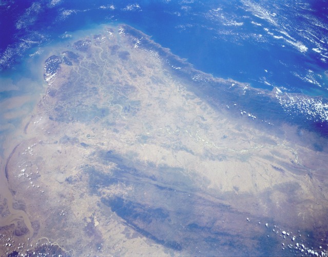 |
| STS059-L13-088 Irrawaddy River, Burma April 1994 The large delta created by the southward-flowing Irrawaddy River is a major rice-growing region of the world. The British were instrumental in establishing the infrastructure for Burma to develop rice crops in the Irrawaddy delta. This southwest-looking, low-oblique photograph shows the broad expanse of the meandering river and numerous sandbars (highly reflective areas) flanked by the forested Arakan Mountains to the west and the Pegu Range to the east. Several major faults trend north-south within the Pegu Range. This photograph reveals the general landscape before the monsoon season. The tans and light browns are typical of an arid landscape; most of the green vegetation at this time of year is found on the two mountain ranges and in permanent mangrove stands in the Irrawaddy delta. Similar to northeast India and Bangladesh, this region of Burma is very dependent on monsoons for agriculture. The monsoons usually begin in June and can extend through September and October. The warm monsoon climate and fine alluvial soils produce rice, sugarcane, beans, and other vegetables in the southern Irrawaddy River basin. |
| Images: | All Available Images Low-Resolution 98k |
|
| Mission: | STS059 |
|
| Roll - Frame: | L13 - 88 |
|
| Geographical Name: | MYANMAR (BURMA) |
|
| Features: | IRRAWADDY RIVER DELTA |
|
| Center Lat x Lon: | 17.5N x 95.5E |
|
| Film Exposure: | N | N=Normal exposure, U=Under exposed, O=Over exposed, F=out of Focus |
| Percentage of Cloud Cover-CLDP: | 5 |
|
| Camera:: | LH |
|
| Camera Tilt: | 37 | LO=Low Oblique, HO=High Oblique, NV=Near Vertical |
| Camera Focal Length: | 90 |
|
| Nadir to Photo Center Direction: | SW | The direction from the nadir to the center point, N=North, S=South, E=East, W=West |
| Stereo?: | Y | Y=Yes there is an adjacent picture of the same area, N=No there isn't |
| Orbit Number: | 143 |
|
| Date: | 19940418 | YYYYMMDD |
| Time: | 054510 | GMT HHMMSS |
| Nadir Lat: | 18.3N |
Latitude of suborbital point of spacecraft |
| Nadir Lon: | 96.7E |
Longitude of suborbital point of spacecraft |
| Sun Azimuth: | 203 | Clockwise angle in degrees from north to the sun measured at the nadir point |
| Space Craft Altitude: | 114 | nautical miles |
| Sun Elevation: | 82 | Angle in degrees between the horizon and the sun, measured at the nadir point |
| Land Views: | BASIN, VALLEY, HILL, FOREST |
|
| Water Views: | RIVER, DELTA, SEDIMENT |
|
| Atmosphere Views: | |
|
| Man Made Views: | AGRICULTURE |
|
| City Views: | |
|
Photo is not associated with any sequences | ||
| NASA Home Page |
JSC Home Page |
JSC Digital Image Collection |
Earth Science & Remote Sensing |
|
This service is provided by the International Space Station program and the JSC Earth Science & Remote Sensing Unit, ARES Division, Exploration Integration Science Directorate.

|