
Geographic Region: SYRIA
Feature: MTS, RES., AGRICULTURE,DESERT
|
Geographic Region: SYRIA Feature: MTS, RES., AGRICULTURE,DESERT |
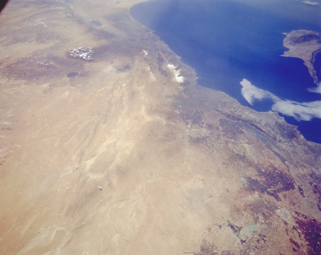 |
| STS059-L06-077 Eastern Syria April 1994 Syria (the western third of the country included in this photograph) is an excellent example of a country where climate and topography dictate which regions of the country are developed. The Mediterranean coastal area of Syria receives adequate rainfall; irrigation is not required. Toward the interior in the rain shadow, or leeward side of the mountains, agriculture is possible, but in many cases irrigation is required. The darker, brownish areas indicate subregions where land is being used for agriculture. Cotton and wheat are the two leading crops grown in the northwest corner of Syria. Aleppo (Halab), a city of approximately 2 million located along an old caravan route, is barely visible near the northern edge of the photograph. This region is the intersection of three major tectonic plates (African, Arabian, and Eurasian). Although the surface manifestation of these plate boundaries tends to be subtle, the boundaries can be seen from the Dead Sea Rift Valley along a line of low, northeast-southwest-trending mountain ridges through the desert area to the east. The light brown area along the southeastern part of the photograph is the Syrian Desert. Many nomadic people graze their sheep, camels, and goats in this desert. |
| Images: | All Available Images Low-Resolution 76k |
|
| Mission: | STS059 |
|
| Roll - Frame: | L06 - 77 |
|
| Geographical Name: | SYRIA |
|
| Features: | MTS, RES., AGRICULTURE,DESERT |
|
| Center Lat x Lon: | 35.0N x 37.5E |
|
| Film Exposure: | N | N=Normal exposure, U=Under exposed, O=Over exposed, F=out of Focus |
| Percentage of Cloud Cover-CLDP: | 5 |
|
| Camera:: | LH |
|
| Camera Tilt: | 41 | LO=Low Oblique, HO=High Oblique, NV=Near Vertical |
| Camera Focal Length: | 90 |
|
| Nadir to Photo Center Direction: | SW | The direction from the nadir to the center point, N=North, S=South, E=East, W=West |
| Stereo?: | Y | Y=Yes there is an adjacent picture of the same area, N=No there isn't |
| Orbit Number: | 97 |
|
| Date: | 19940415 | YYYYMMDD |
| Time: | 094016 | GMT HHMMSS |
| Nadir Lat: | 36.2N |
Latitude of suborbital point of spacecraft |
| Nadir Lon: | 38.6E |
Longitude of suborbital point of spacecraft |
| Sun Azimuth: | 188 | Clockwise angle in degrees from north to the sun measured at the nadir point |
| Space Craft Altitude: | 114 | nautical miles |
| Sun Elevation: | 63 | Angle in degrees between the horizon and the sun, measured at the nadir point |
| Land Views: | COAST, MOUNTAIN, DESERT, HILL |
|
| Water Views: | SEA, RIVER |
|
| Atmosphere Views: | |
|
| Man Made Views: | |
|
| City Views: | |
|
Photo is not associated with any sequences | ||
| NASA Home Page |
JSC Home Page |
JSC Digital Image Collection |
Earth Science & Remote Sensing |
|
This service is provided by the International Space Station program and the JSC Earth Science & Remote Sensing Unit, ARES Division, Exploration Integration Science Directorate.

|