
Geographic Region: TURKEY
Feature: TAURUS MTS, RES., CYPRUS
|
Geographic Region: TURKEY Feature: TAURUS MTS, RES., CYPRUS |
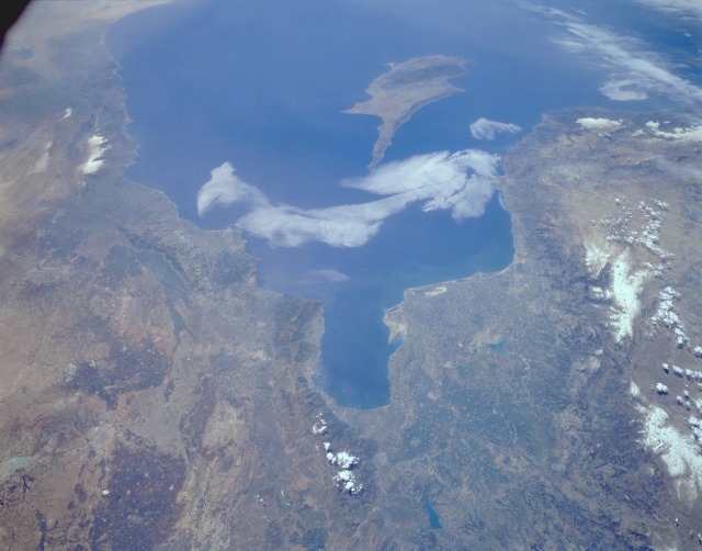 |
| STS059-L06-076 Plain of Adana, South-Central Turkey April 1994 Two major agricultural areas are shown in this southwest-looking photograph of south-central Turkey and northwest Syria. The extensive Plain of Adana, a region that produces many varieties of cotton, is located northwest of the Gulf of Iskenderun (the roughly rectangular-shaped gulf near the center of the photograph) and is irrigated by the Seyhan River. Adana, the largest city in the region, can be seen midway between the Gulf of Iskenderun and the Taurus Mountains to the west, whose major peaks exceed 11 000 feet (3300 meters) above sea level. The Amanus Mountains form a barrier along the eastern flank of the Adana Plain, extending in a north-south orientation along the eastern shore of the Gulf of Iskenderun. East of the Amanus Mountains, the second major city of Syria, Aleppo, is set in a well-watered agricultural region, which can be identified by the darker, brownish areas. The lighter, circular features within the darker areas are small towns and villages. The coastlines of Syria, Lebanon, and Israel are visible along the eastern Mediterranean Sea. The small, strategically situated island of Cyprus can be seen off the Turkish and Syrian coasts. |
| Images: | All Available Images Low-Resolution 80k |
|
| Mission: | STS059 |
|
| Roll - Frame: | L06 - 76 |
|
| Geographical Name: | TURKEY |
|
| Features: | TAURUS MTS, RES., CYPRUS |
|
| Center Lat x Lon: | 36.5N x 35.5E |
|
| Film Exposure: | N | N=Normal exposure, U=Under exposed, O=Over exposed, F=out of Focus |
| Percentage of Cloud Cover-CLDP: | 10 |
|
| Camera:: | LH |
|
| Camera Tilt: | 45 | LO=Low Oblique, HO=High Oblique, NV=Near Vertical |
| Camera Focal Length: | 90 |
|
| Nadir to Photo Center Direction: | SW | The direction from the nadir to the center point, N=North, S=South, E=East, W=West |
| Stereo?: | Y | Y=Yes there is an adjacent picture of the same area, N=No there isn't |
| Orbit Number: | 97 |
|
| Date: | 19940415 | YYYYMMDD |
| Time: | 093945 | GMT HHMMSS |
| Nadir Lat: | 37.8N |
Latitude of suborbital point of spacecraft |
| Nadir Lon: | 36.9E |
Longitude of suborbital point of spacecraft |
| Sun Azimuth: | 184 | Clockwise angle in degrees from north to the sun measured at the nadir point |
| Space Craft Altitude: | 114 | nautical miles |
| Sun Elevation: | 62 | Angle in degrees between the horizon and the sun, measured at the nadir point |
| Land Views: | MOUNTAIN, COAST, PLAIN, FAULT |
|
| Water Views: | SEA, GULF, RIVER |
|
| Atmosphere Views: | |
|
| Man Made Views: | |
|
| City Views: | |
|
Photo is not associated with any sequences | ||
| NASA Home Page |
JSC Home Page |
JSC Digital Image Collection |
Earth Science & Remote Sensing |
|
This service is provided by the International Space Station program and the JSC Earth Science & Remote Sensing Unit, ARES Division, Exploration Integration Science Directorate.

|