
Geographic Region: TURKMENISTAN
Feature: KARA-BOGAZ-GOL BAY, MTS.
|
Geographic Region: TURKMENISTAN Feature: KARA-BOGAZ-GOL BAY, MTS. |
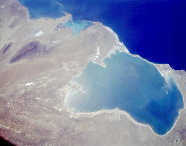 |
| STS059-L06-048 Kara-Bogaz-Gol, Turkmenistan April 1994 The shallow bay of Kara-Bogaz-Gol located in western Turkmenistan can be seen in this low-oblique, south-southwest-looking photograph. As an arm of the Caspian Sea (dark blue water), the Kara-Bogaz-Gol acts as a natural evaporation basin, drawing water off the Caspian Sea and depositing salts along the bay shores. In 1979, a dike was built connecting the narrow strips of land on the west side of the bay (visible between the dark blue water of the Caspian Sea and the turquoise water of the bay). The bay is more than 100 miles (160 kilometers) long, is 85 miles (137 kilometers) wide, and covers approximately 7000 square miles (18 000 square kilometers). The average elevation of the Caspian Sea is 92 feet (28 meters) below sea level, whereas the average elevation of the Kara-Bogaz-Gol is 102 feet (31 meters) below sea level. When water levels drop in the Caspian Sea, as happened in the 1980s, the bay has less standing water in its shallow basin than is shown in this photograph. Other features discernible in the photograph include the western escarpment of the Ustyurt Plateau (between the brown and light tan) on the eastern shore of the bay, Krasnovodsk Bay south of the bay, and the dark forest-covered Balkhan Mountains south of the bay and east of Krasnovodsk Bay. |
| Images: | All Available Images Low-Resolution 63k |
|
| Mission: | STS059 |
|
| Roll - Frame: | L06 - 48 |
|
| Geographical Name: | TURKMENISTAN |
|
| Features: | KARA-BOGAZ-GOL BAY, MTS. |
|
| Center Lat x Lon: | 41.0N x 53.5E |
|
| Film Exposure: | N | N=Normal exposure, U=Under exposed, O=Over exposed, F=out of Focus |
| Percentage of Cloud Cover-CLDP: | 0 |
|
| Camera:: | LH |
|
| Camera Tilt: | 36 | LO=Low Oblique, HO=High Oblique, NV=Near Vertical |
| Camera Focal Length: | 90 |
|
| Nadir to Photo Center Direction: | SW | The direction from the nadir to the center point, N=North, S=South, E=East, W=West |
| Stereo?: | Y | Y=Yes there is an adjacent picture of the same area, N=No there isn't |
| Orbit Number: | 96 |
|
| Date: | 19940415 | YYYYMMDD |
| Time: | 080938 | GMT HHMMSS |
| Nadir Lat: | 41.8N |
Latitude of suborbital point of spacecraft |
| Nadir Lon: | 54.6E |
Longitude of suborbital point of spacecraft |
| Sun Azimuth: | 174 | Clockwise angle in degrees from north to the sun measured at the nadir point |
| Space Craft Altitude: | 114 | nautical miles |
| Sun Elevation: | 58 | Angle in degrees between the horizon and the sun, measured at the nadir point |
| Land Views: | DESERT, PLATEAU, COAST |
|
| Water Views: | GULF, SEA, BAY |
|
| Atmosphere Views: | |
|
| Man Made Views: | |
|
| City Views: | |
|
Associated Photos in Sequence:  Photo #: STS51F-40-64 Photo #: STS51F-40-64Description: TURKMENISTAN, KARA-BOGAZ-GOL--1985; INLET WATER LEVEL INCREASE Sequence ID: 11A  Photo #: STS059-L06-48 ** Currently displayed photo ** Photo #: STS059-L06-48 ** Currently displayed photo ** Description: TURKMENISTAN, KARA-BOGAZ-GOL--1994; INLET WATER LEVEL INCREASE Sequence ID: 11B  Photo #: STS073-701-33 Photo #: STS073-701-33Description: TURKMENISTAN, KARA-BOGAZ-GOL--1995; INLET WATER LEVEL INCREASE Sequence ID: 11C | ||
| NASA Home Page |
JSC Home Page |
JSC Digital Image Collection |
Earth Science & Remote Sensing |
|
This service is provided by the International Space Station program and the JSC Earth Science & Remote Sensing Unit, ARES Division, Exploration Integration Science Directorate.

|