
Geographic Region: USA-WYOMING
Feature: GREAT DIVIDE BASIN
|
Geographic Region: USA-WYOMING Feature: GREAT DIVIDE BASIN |
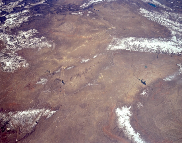 |
| STS059-L03-098 The Great Divide Basin, Wyoming, U.S.A. April 1994 The Great Divide Basin of southwestern Wyoming, covering 3500 square miles (9065 square kilometers), is featured in this southwest-looking, low-oblique, panoramic photograph. The arid, windy center of the basin--sometimes called the Red Desert Basin because of its red soil and sand dunes--contains sand dunes and saline lakebeds. The basin, topographically closed with little precipitation, would probably contain a large lake in its center if it were in an area of high precipitation. In the 1880s the basin was considered the easiest route for westward settlers to use across the Rocky Mountains; today it is one of the most important pronghorn antelope ranges in the state. Visible are the snow-covered Laramie Mountains (bottom left) and, to their north-northwest, the Bighorn Mountains and the southern portion of the Bighorn Basin. Viewing southwest from the Boysen Reservoir just south of Bighorn Basin are the Wind River Range, the Wyoming Range, the Salt River Range, and Bear Lake (barely discernible). Apparent are the eastern extension of the Uinta Mountains of northern Utah (top center) and the northern portions of the Sierra Madre and Medicine Bow Mountains (left center). |
| Images: | All Available Images Low-Resolution 273k |
|
| Mission: | STS059 |
|
| Roll - Frame: | L03 - 98 |
|
| Geographical Name: | USA-WYOMING |
|
| Features: | GREAT DIVIDE BASIN |
|
| Center Lat x Lon: | 42.5N x 108W |
|
| Film Exposure: | N | N=Normal exposure, U=Under exposed, O=Over exposed, F=out of Focus |
| Percentage of Cloud Cover-CLDP: | 0 |
|
| Camera:: | LH |
|
| Camera Tilt: | 46 | LO=Low Oblique, HO=High Oblique, NV=Near Vertical |
| Camera Focal Length: | 90 |
|
| Nadir to Photo Center Direction: | SW | The direction from the nadir to the center point, N=North, S=South, E=East, W=West |
| Stereo?: | Y | Y=Yes there is an adjacent picture of the same area, N=No there isn't |
| Orbit Number: | 119 |
|
| Date: | 19940416 | YYYYMMDD |
| Time: | 180901 | GMT HHMMSS |
| Nadir Lat: | 43.8N |
Latitude of suborbital point of spacecraft |
| Nadir Lon: | 106.5W |
Longitude of suborbital point of spacecraft |
| Sun Azimuth: | 155 | Clockwise angle in degrees from north to the sun measured at the nadir point |
| Space Craft Altitude: | 114 | nautical miles |
| Sun Elevation: | 54 | Angle in degrees between the horizon and the sun, measured at the nadir point |
| Land Views: | BASIN, MOUNTAIN, FAULT |
|
| Water Views: | |
|
| Atmosphere Views: | |
|
| Man Made Views: | |
|
| City Views: | |
|
Photo is not associated with any sequences | ||
| NASA Home Page |
JSC Home Page |
JSC Digital Image Collection |
Earth Science & Remote Sensing |
|
This service is provided by the International Space Station program and the JSC Earth Science & Remote Sensing Unit, ARES Division, Exploration Integration Science Directorate.

|